author.travelffeine.com

Category: Destinations

Explore destinations around the world through travels at Travelffeine. There are so many incredible places to be discovered!

  • Hiking The Narrows in Spring at Zion National Park

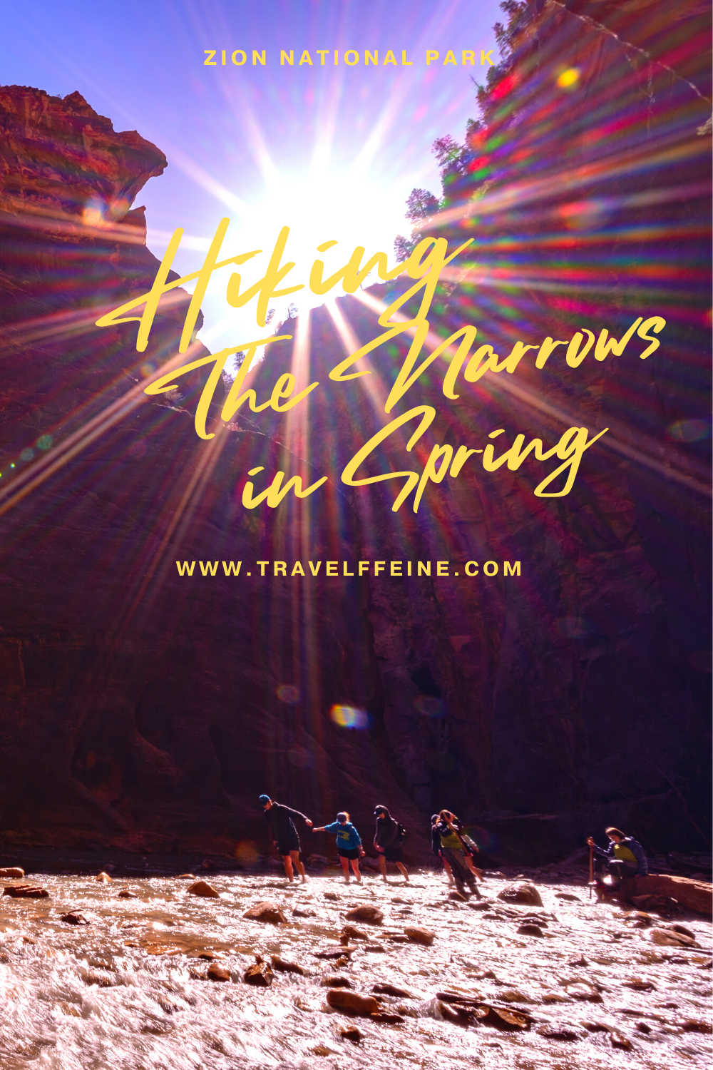
    Hiking The Narrows at Zion National Park is an experience you’ll never forget! The same could be said about hiking Angels Landing, but that’s for other heart-pounding reasons. The Narrows is the poster child for the saying, “it’s not the destination, it’s the journey.” 

    It isn’t just another trail to a beautiful vista or natural monument. It’s more about wandering up a river than reaching any particular destination. That’s part of its beauty. That and you’re hiking up the Virgin River the entire time! It’s guaranteed to be something you and your family talk about for years to come.

    The Narrows Bottom Up Day Hike

    This article is about hiking The Narrows from the Temple of Sinawava (also referred to as the bottom-up hike).  You can do a longer 16-mile-through hike, but it requires a permit.  The day hike in this post does not require a wilderness permit.

    Shuttle System

    Zion National Park operates on the shuttle system for most of the year. Starting in March, you are not permitted to drive your vehicle along the Zion Canyon Scenic Drive. Instead, you take a shuttle on a first-come, first-served basis. 

    For a while, you needed to reserve your time slot. Currently, Zion eliminated the need to purchase and reserve a shuttle ticket in advance. It is free but get there early. Check the park’s shuttle schedule for current hours of operation. Try to get to the park as early as possible to avoid the crowds.

    You also want to pay attention to the last shuttle, so you don’t miss it. If you miss the last shuttle of the day, you’ll have to walk back to your car. Depending on where you are in the park, that could be a long walk. So don’t miss it!

    Parking

    There is parking at the Visitor Center, but it fills up quickly! Usually, by 10 a.m., it is full. That is another reason for getting to Zion early and catching the first shuttle. If you can’t find parking at the Visitor Center, you can look for paid parking in the town of Springdale. The Springdale Shuttle takes visitors to the Zion National Park Visitor Center, and you can then catch a Zion National Park shuttle from there.

    Getting to the Trailhead

    To hike The Narrows, you want to take Zion’s shuttle to the last stop and get off at the Temple of Sinawava stop.  There is a restroom here, and the trail begins along the Zion Riverside Walk paved trail.

    The Narrows at Zion National Park

    About The Narrows Hike

    Trail Length: 5.0-10.0 miles (roundtrip)
    It depends on how far you decide to hike. The area referred to as “Wall Street” is about a 5.0-mile round trip hike. Hiking to Big Spring is 10 miles round trip. You can, of course, only hike in 1-2 miles and turn around. It’s up to you!

    Approx. Hiking Time: 4-8 hours
    Again, it will depend on how far you want to hike up the river and how many photo stops and snack breaks you take.

    Elevation Gain: No significant elevation gain.
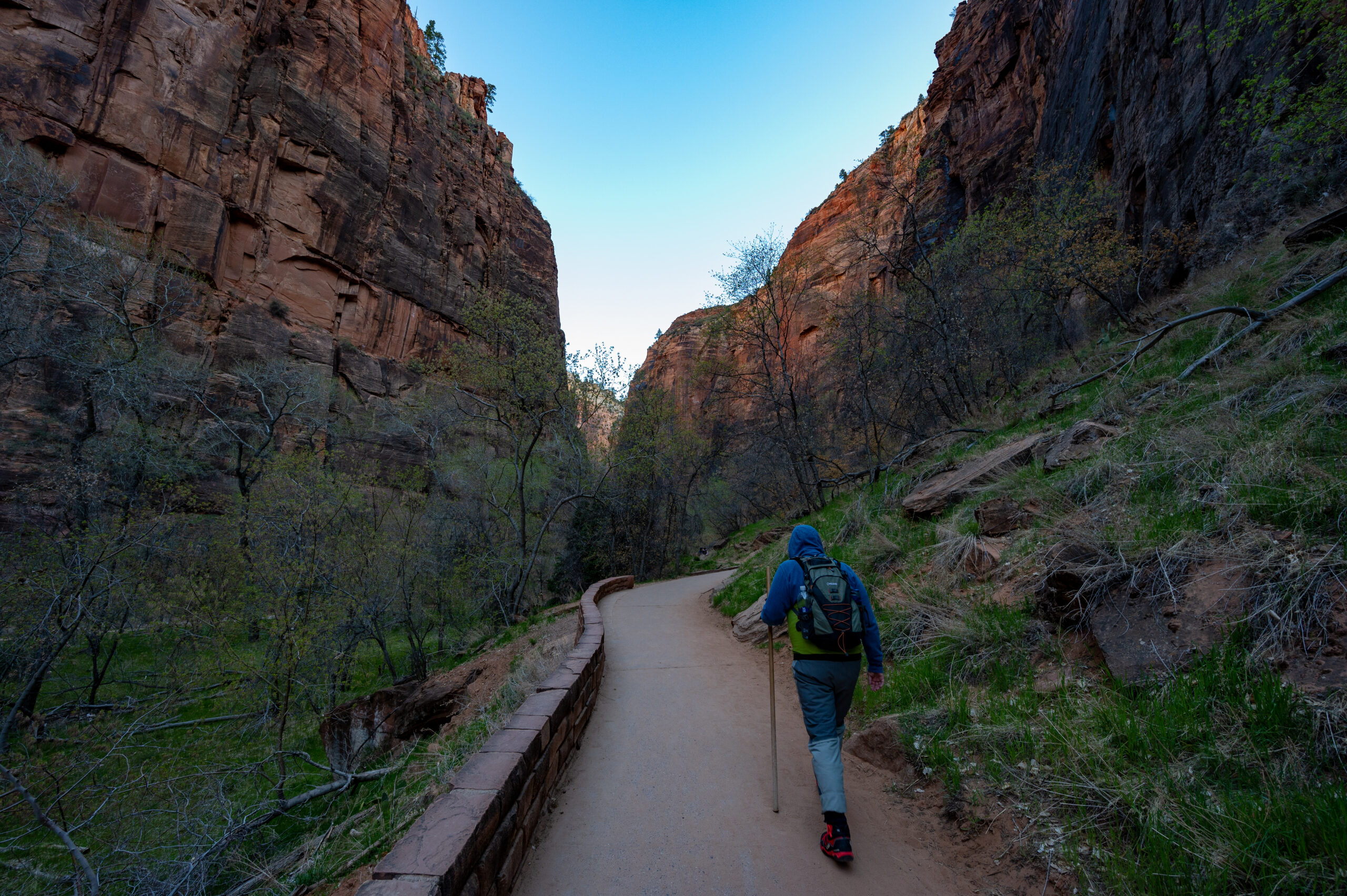
    You’re walking up a canyon river bed with only slight increases in elevation. The first mile of the hike is along the paved Riverside Walk. The rest of the time, you are hiking up a rocky riverbed.

    Trail Difficulty Rating: Moderate to Strenuous
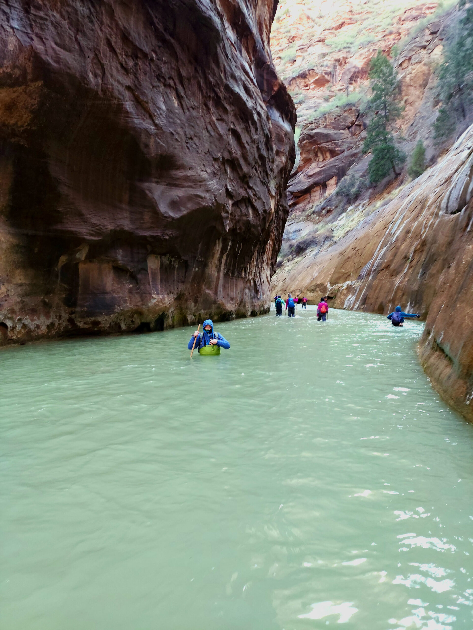
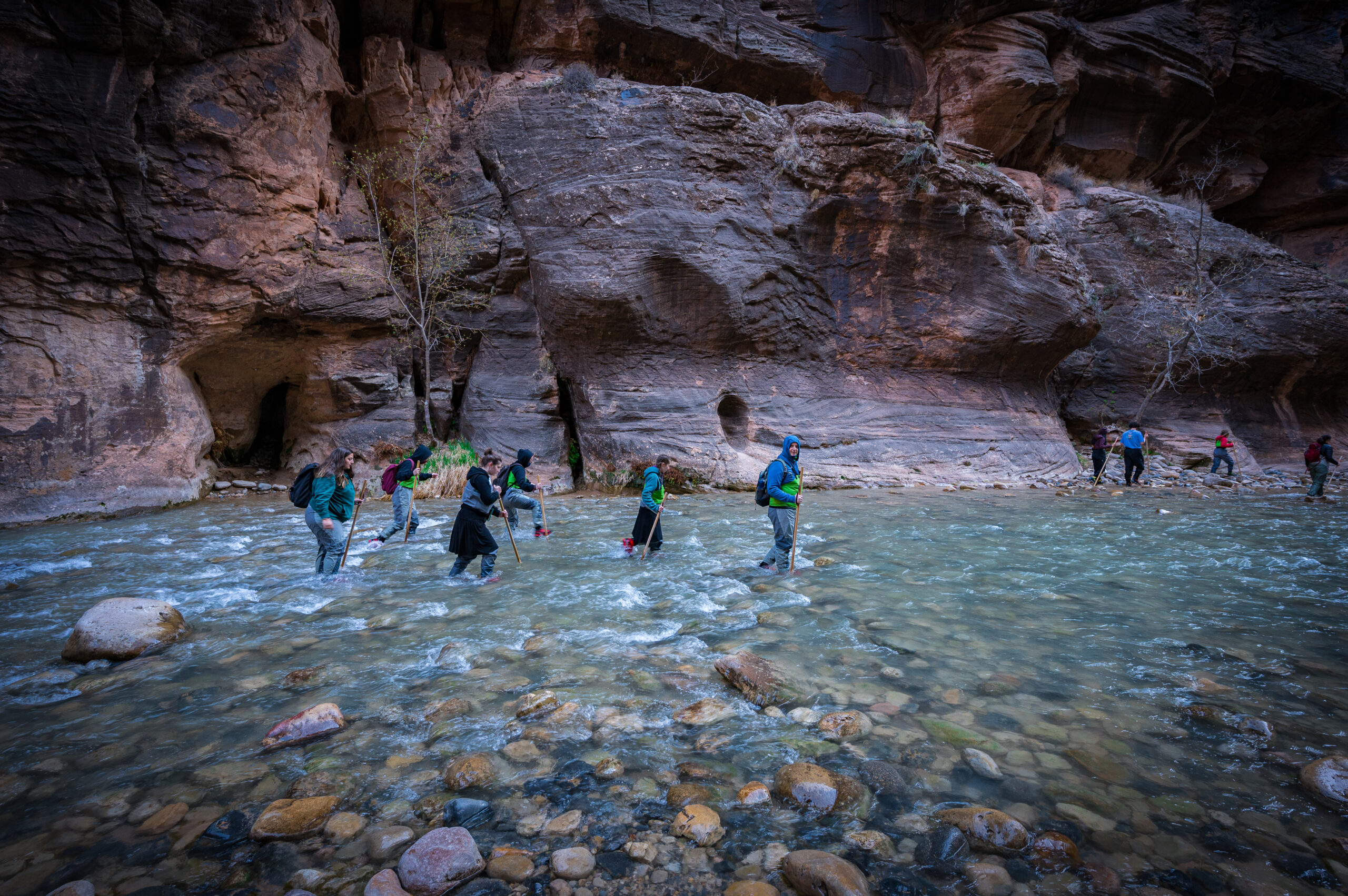
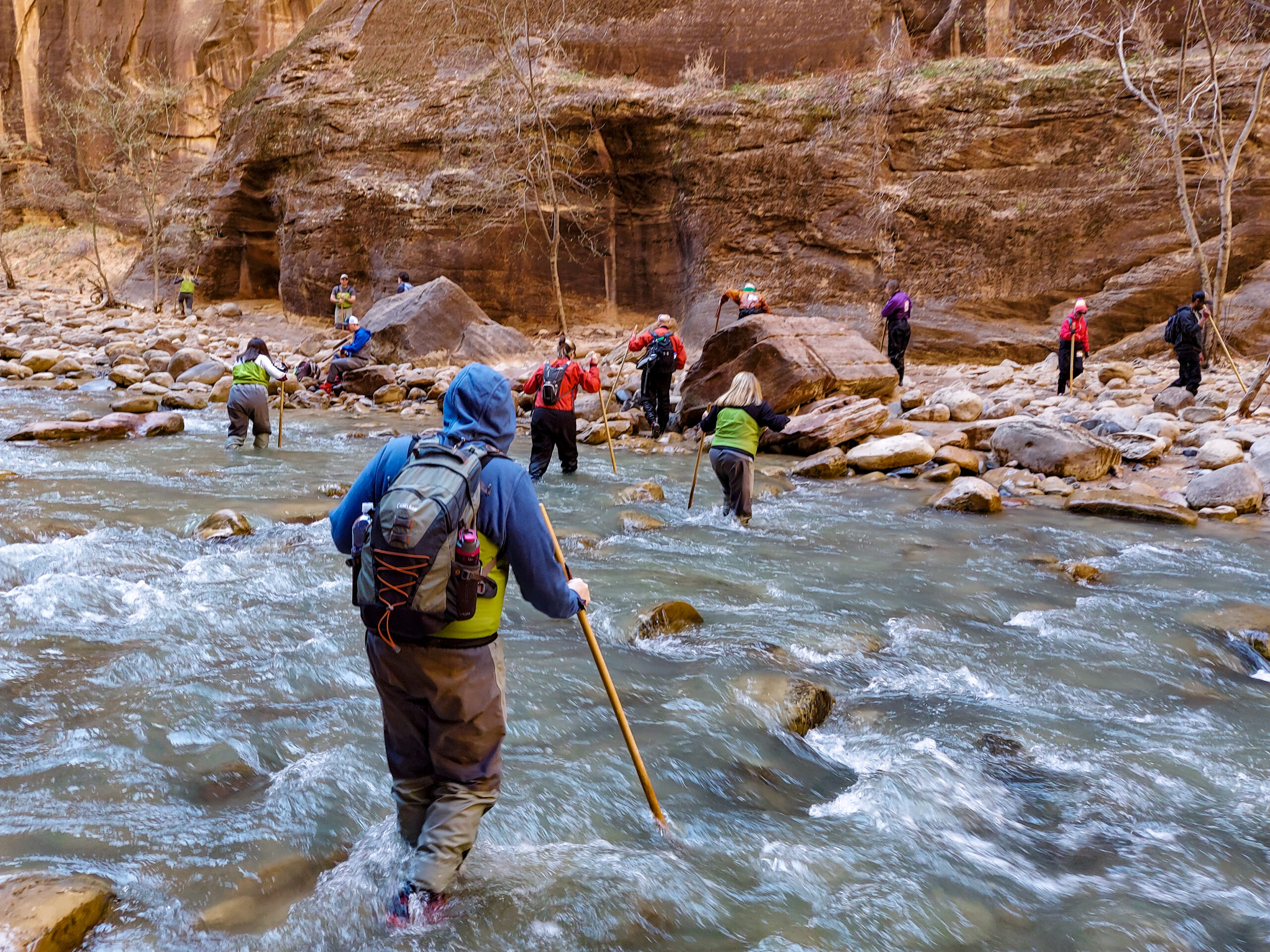
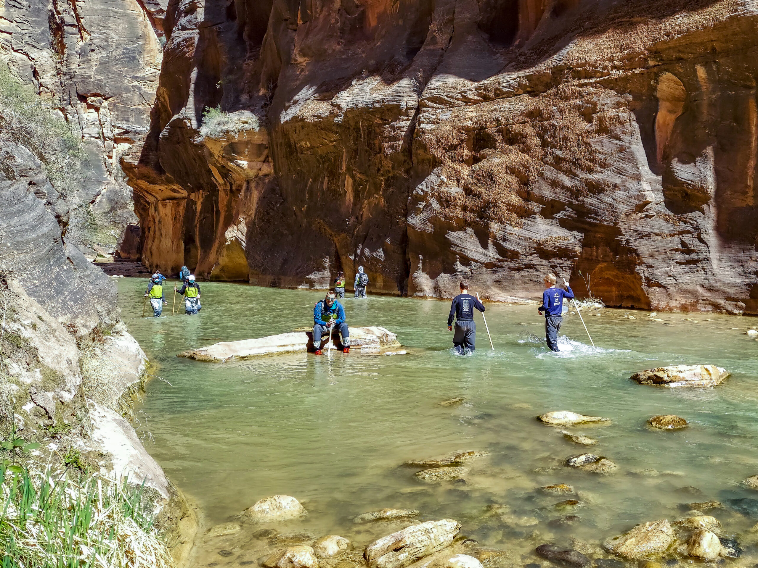
    The unique location of this hike makes it more difficult. You hike through a river, upstream, over slippery rocks, around boulders, and sometimes in waist-deep water. Depending on water levels, the current pulls at you more strongly too. All these factors combined make this a more challenging hike. That said, I saw families doing this. Just take your time and help each other out.

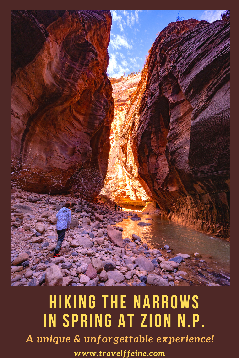
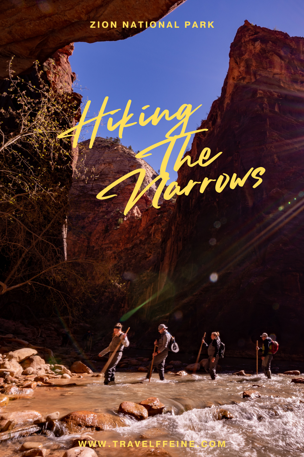
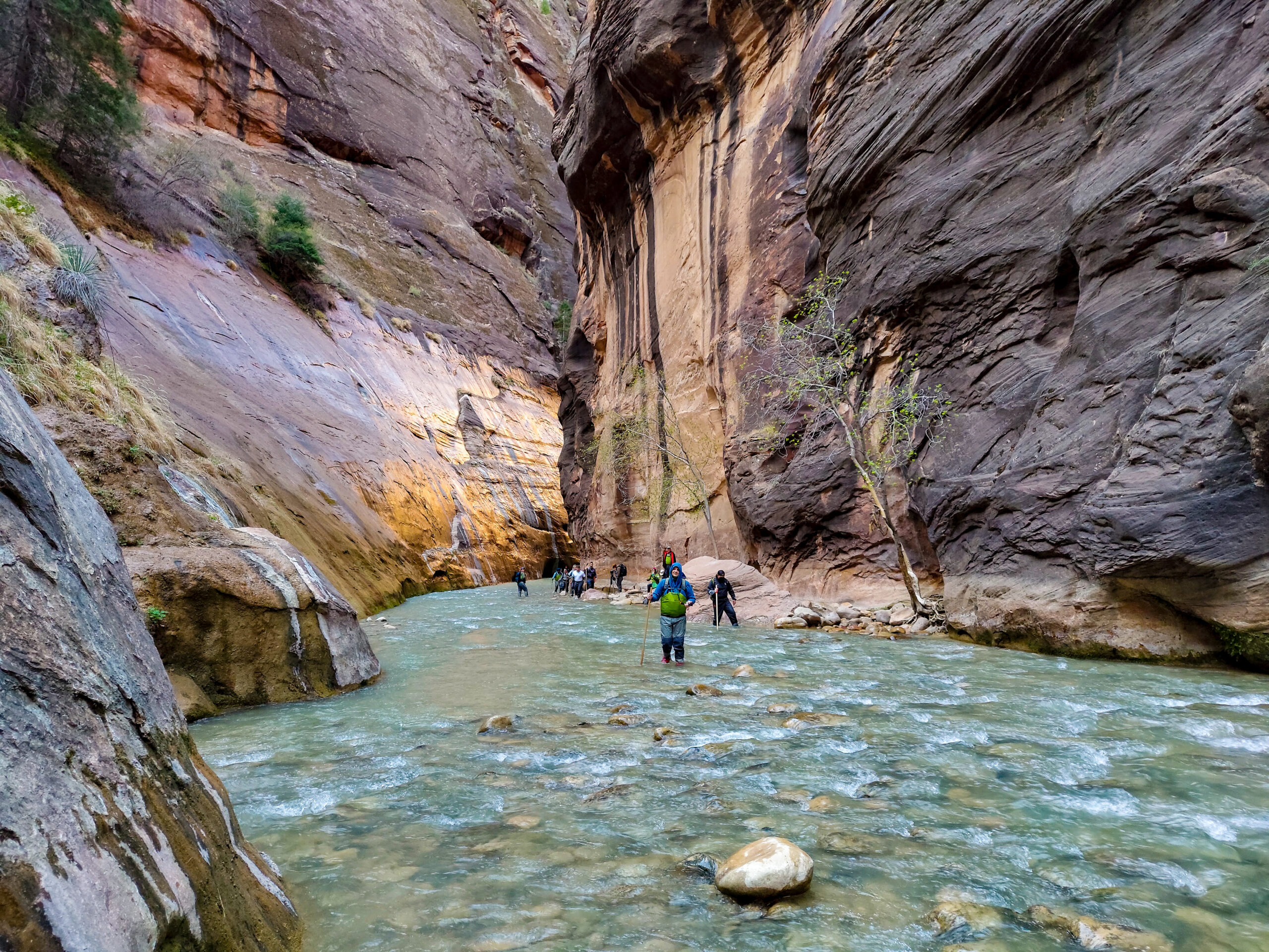
    Features: A unique hike up the Virgin River through the narrowest part of Zion Canyon. Gorgeous red canyon walls, waterfalls, and beautiful displays of light as the sun reflects off the canyon walls.

    Restroom Facilities: The only restrooms are at the Temple of Sinawava shuttle stop. There are no other restrooms along the hike, and all solid waste must be packed out.

    Riverside Walk at Zion Narrows Bundled Up

    What To Bring

    Water.  Do not take this hike or any hike without water. The river water is unsafe to drink, and although it typically is cooler in the canyon, it still gets hot in the summer. Make sure to bring plenty of water for everyone in your group.

    Trekking Poles.  A hiking pole or two helps navigate the slippery riverbed. It is also helpful for checking water depths.

    Sunscreen.  You may be surprised by how much sunlight filters down to you and reflects off the water.

    Snacks/Lunch. I highly recommend you pack a lunch, but make sure to bring snacks and drinks at a minimum.  It may depend on what time of day you start your hike whether or not you want to bring lunch. We had a morning shuttle time and hiked this early, eating lunch deep inside the canyon. We also had snacks, and we were thankful for all of it. You work up an appetite hiking up a river!

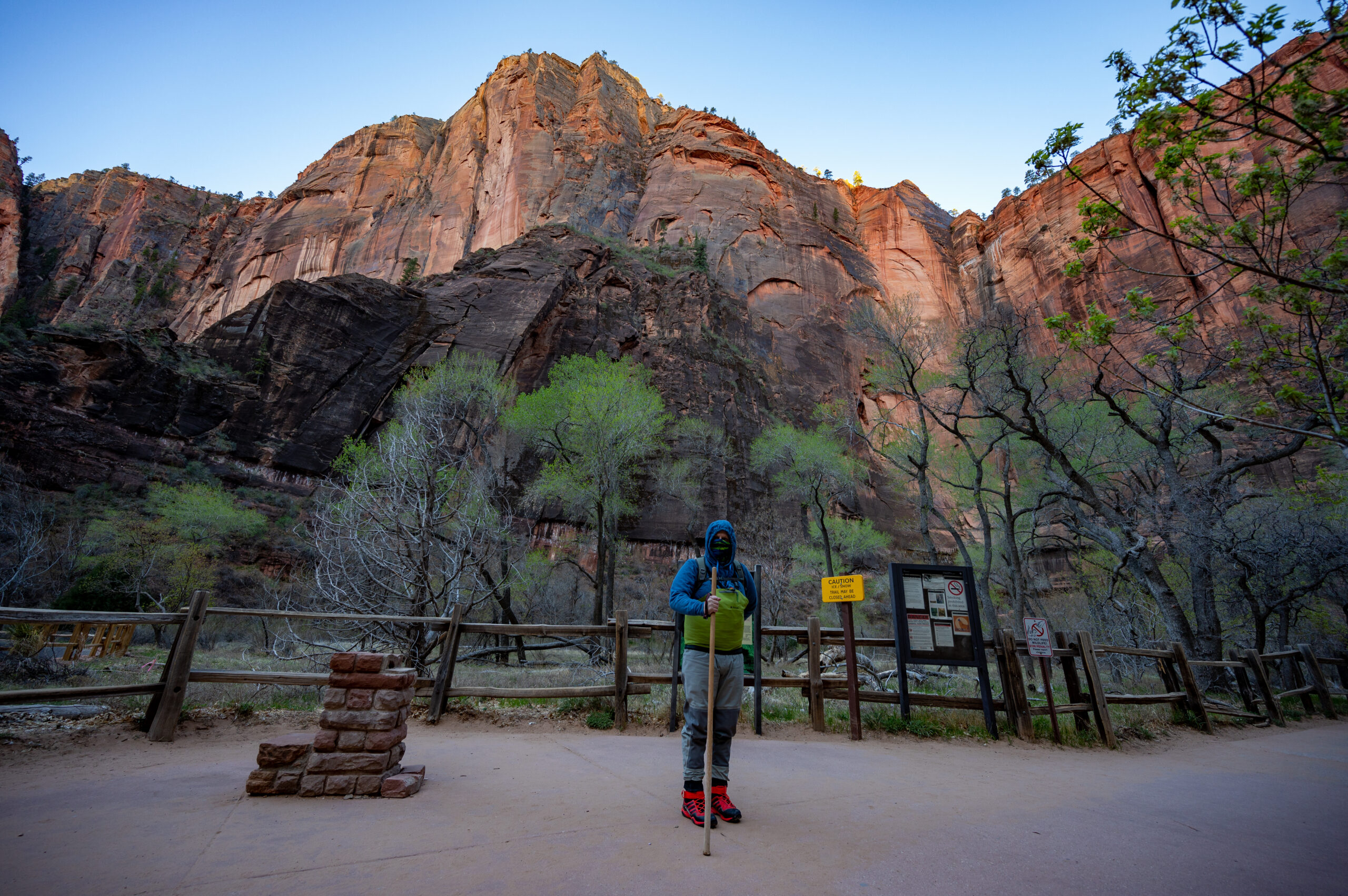
    Waterproof Gear. This isn’t a requirement, but I highly recommend it if you’re hiking in the spring or winter. Cameras or electronic gear you want to bring will be best kept in a waterproof backpack. A waterproof bag is also good for sandwiches and snacks.

    Close-toed shoes: Rent waterproof shoes at one of the outfitters outside Zion (see a list below under Tips) or wear tennis shoes or hiking boots. You are bound to stub your toe on a rock below the surface. Flipflops are a big no-no.

    Layers. Wear layers of clothing. It might be cold in the morning but hot by the afternoon. Additionally, the narrower sections of the slot canyon are shaded and cool. So although it can be over 100 degrees out in the sun, it is significantly colder in the river in the shade.

    Important Information

    You will get wet. I know, surprise, surprise.  You can rent waterproof gear or hike in your clothes and shoes, but again, you will get wet.  It was spring when we hiked this, and it was in the upper 30s in the morning. We thought the money spent on our waterproof pants and shoes was one of the best decisions we ever made as we took that first step into the river.

    You may also want to rent a waterproof backpack or bring your own. Renting a large waterproof bag to carry our gear and food was money well spent! I had expensive camera gear, which I did not want to get wet were I to take a tumble in the river.

    There is an inherent risk involved whenever you’re in a river or a slot canyon. Zion closes The Narrows hike if the levels are too high or if the National Weather Service issues a flash flood warning. Check with Zion National Park for the weather forecast and water levels ahead of time.

    Stop at the Visitor Center on the day of your hike or the day before and ask about the most up-to-date conditions and get tips on what to do if you’re in a thunderstorm or potential flash flood. This isn’t Disneyland, this is nature, and it’s often unpredictable. Zion park rangers will do their best to mitigate the dangers, but there is always an inherent risk, and they can’t always accurately predict these things.

    Deep Water in The Narrows at Zion National Park

    My Experience Hiking The Narrows in Spring

    6:30 a.m. In Line at Zion Outfitters

    We were waiting in line to rent waterproof gear at Zion Outfitters. There were around ten people ahead of us in line. We’re nervous we’ll miss our shuttle window, but an employee said not to worry. They’ll still let us on the shuttle even if we’re a little late. We rented the Bib Package and waterproof shoes, and a waterproof backpack.  Money well spent!

    8:30 a.m. Starting our hike along Zion’s Riverside Walk

    We begin our hike along the Riverside Walk. It’s freezing out, and we are layered up underneath our waterproof bibs and wearing jackets over the bibs.  The wind was blowing, and it was in the upper 30s when we started. I am nervous about getting in the water. It’s a 1-mile walk along the paved Riverside Walk before we reach the end of the trail and the beginning of the river portion in The Narrows.

    Zion Riverside Walk trail

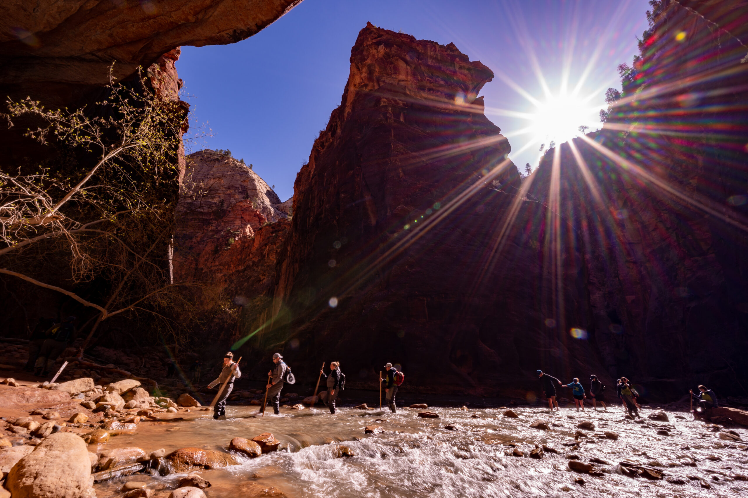
    9:00 a.m. Entering The Virgin River

    We reach the end of the Riverside Walk Trail and climb down to the river to begin our hike up The Narrows at Zion National Park.  It’s exciting as we take the first step into the river. I hesitantly put one foot in, then the other, and wait to see if water leaks in.  It doesn’t! It only feels a little cool on the outside of my feet and isn’t freezing as I expected. I couldn’t be happier with my waterproof gear!

    Hiking up the Virgin River

    Never Alone in The Narrows

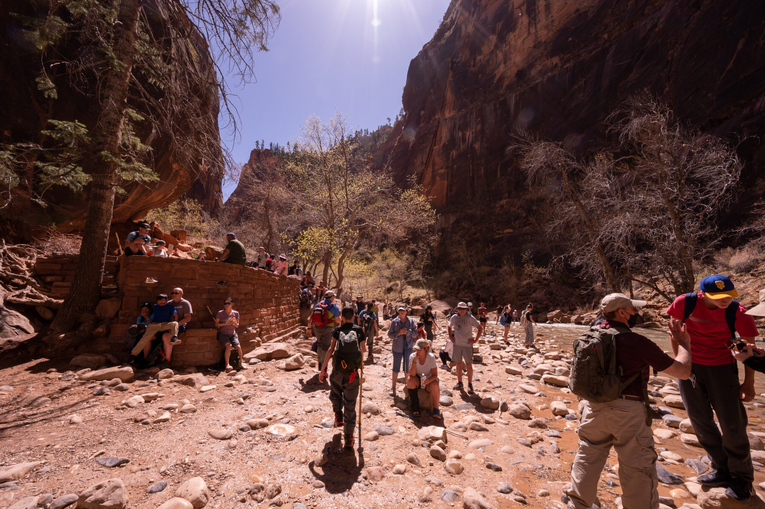
    One thing is true about the hike up The Narrows–you are never alone.  Even with our early morning start, there are at least 30 other hikers, and the number continues to grow to 100’s by the afternoon.  Early morning is your best bet if you want to get photos with the least number of people. 

    This is a community hike; we’re in this together, laughing and sharing in this utterly unique hiking experience. There were so many photo stops along the way! Look in both directions to capture how the sunlight filters into Zion Canyon. The colors change throughout your walk with the amount of light shining in.

    crossing small rapids hiking in The Narrows

    Lunch and Snack Breaks

    There are a few different places along The Narrows where you can get out of the water and find a small patch of dry land to take a snack break or a lunch break.  If you start before lunchtime, I highly recommend packing a lunch. It is nice to take a break and enjoy the surroundings. It’s also easier to stop for a snack when you’re not actively walking up a river.

    Rest Break in the Virgin River

    Look Up

    Make sure to look up while hiking The Narrows. Zion Canyon towers above and looks so beautiful against the blue sky. Plus, you may find a ray of sunlight seeping down to the river, and you can basque in its glow as I saw other hikers doing. It gets a little chilly in the shaded parts of the canyon, so the sunlight is a welcome sight.

    2:30 p.m. Back on Dry Land

    We’re back where we started on the Riverside Walk. The trail is much more crowded now, with hundreds of people sitting around the end of the trail relaxing in the sun or playing in the river.  It is now in the 80s, and I can’t wait to be out of my gear and back into shorts! The hike back was faster, which always seems to be the case. You know where you’re headed on the walk back, and you’ve already taken most of the photos you want.

    Riverside Walk at Zion National park

    Overall Thoughts About Hiking Up The Narrows

    Who would have thought it could be so fun to spend the day hiking up a river? Not me. However, The Narrows was such a fun way to spend the day. It was beautiful to see the natural designs in the stone where the water carved it out and to gaze up at the canyon walls towering thousands of feet above. I think it is something you must experience for yourself to appreciate what the hype is all about.

    We visited in early spring, and water levels were still relatively low. A few deep spots went up to our waists, so I can only imagine what the current and levels are like a little later in the spring. Always check with the visitor center for the current conditions and prepare accordingly.

    A walk up the Virgin River

    Tips for Hiking The Narrows at Zion

    Reserve Your Gear Head of Time

    If possible, reserve your waterproof gear ahead of time. We did not have a reservation, but we got in line before Zion Outfitters opened, and we were fitted and checked out in around 30-minutes. It helped that they are right outside the main entrance to Zion National Park.

    Go Early

    Get to Zion National Park early to beat the heat and crowds and get parking so you won’t feel rushed for time or worry about missing the last shuttle out.

    Planning Your Day

    Don’t plan any other strenuous hikes for the day or any other hikes for that matter. If you’re anything like me, your feet will be sore after hiking over rocks for hours. I suggest grabbing some pizza and enjoying a leisurely day after your hike up The Narrows.

    Where to Eat

    The best tip I can give you is to drive to La Verkin and eat at River Rock Roasting Company.  They have incredible pizza with a view, plus the best cinnamon rolls you’ll ever eat.  They also sell their freshly roasted coffee beans to take with you. It’s your one-stop-shop for breakfast, lunch, and dinner! 

    Additional Articles You May Enjoy

    Hiking The Narrows in Spring
    Hiking The Narrows in Spring at Zion National Park
    Hiking The Narrows at Zion
  • Peneda-Geres National Park: A Day Trip From Porto

    Peneda-Geres National Park is Portugal’s only National Park, and it is well worth visiting! Go for a hike, breathe in the fresh air, admire one or more of the many waterfalls within the park, and maybe even see a goat or two along the way! In as little as 1.5 hours, you can drive from Porto to Peneda-Geres National Park and escape the hustle and bustle of the city for a break in nature.

    This article is all about how to take a one-day self-driving road trip from Porto to Peneda-Gerês National Park. I share the itinerary I used and some tips and information for planning your trip, setting expectations, and what to do if you have more time. 

    Planning Your Day Trip to Peneda-Geres National Park

    First, accept that you cannot see it all.  

    With only one day to drive from Porto to Peneda-Geres National Park and make the return back to Porto, you will need to decide what’s important for you to see. Research the hikes, waterfalls, and stops you’re most interested in, and pick one or two. Then, enjoy the drive.

    Plan for extra time between stops.

    As with most national parks, whether in the U.S. or abroad, the roads inside the park are typically narrower and have much slower speed limits than outside the park. Although the distance between stops may not be very far, you need to plan for it to take longer than you expect, especially if it is busier during your visit.

    Points of Interest Inside Peneda-Geres National Park

    We thoroughly enjoyed our day trip, and I know you will too if you decide to follow it. However, I also want to provide some additional options for things to see and do to help you tailor your trip according to your interests. 

    Waterfalls

    There are so many waterfalls inside this park, so here are just a few to consider seeing.

    • Cela Cavalos
    • Cascata do Arado
    • Lagoa do Poco Negro
    • Poco Azul
    • Fecha das Barjas (Tahiti waterfalls)
    • Portela do Homem 

    Hiking

    With over 300 trails in Peneda-Geres National Park, there are too many to list. However, I will list a few links to get you started in your research. 

    • Poço Azul Loop Starting at Cascata do Arado (~5.5 miles, moderate)
    • Miradouro da Pedra e Cascada de Rajada (easy ~2 mile hike starts near the town of Ermida and takes you to a waterfall)
    • Giera Romana (Walking Trail for the old Roman Road) You can walk the old Roman Road from Braga, but I doubt you’ll have time for that. Instead, I suggest hiking a portion from Campo do Geres to Portela do Homem. You could also park on the Spanish side near Portela do Homem and walk a short part of the trail there.
    • Ponte da Misarela (0.5 miles, easy hike to a historic bridge and waterfall)
    • Calcedónia Fault (A Fenda da Calcedónia 5.5 miles, a strenuous hike requiring some rock scrambles and bouldering.) You can also hike a 4.1-mile portion that skips the Calcedonia Fault and rock climbing portion. This is still considered a challenging hike. 

    If you’d like to research more trail options or if you have one or two nights to spend inside the park and want a longer hike, this list from All Trails is a good starting point.

    Camping

    You have a lot of great options for camping around Peneda-Geres National Park. Many of these include cabins and hot showers.

    Picturesque Towns to Explore

    There are so many unique towns surrounding Peneda-Geres National Park. Here are a few to consider exploring in combination with your day. These would also be great options for spending a night or two close to the park.
    • Ermida
    • Lindoso
    • Soajo
    • Sistelo
    • Rio Caldo
    Below, I discuss the route we took, our hikes, and the viewpoints we stopped at during our day trip from Porto to Peneda-Geres. You are welcome to follow the route we took using the below map or create a unique itinerary using some of the above-listed points of interest.

    Our Road Trip from Porto to Peneda-Geres National Park

    We spent five nights in Porto during our two-week road trip in Portugal. We took two days to take day trips outside Porto. One was a day trip to see the Douro Valley, and the other was a day trip to Peneda-Gerês National Park. You can read more about additional day trip options and planning a road trip in Portugal in this article.

    We left Porto early in the morning while it was dark out and most of the city was still asleep. I enjoy seeing a city early in the morning. You catch the bakery getting their deliveries, you see the early morning commuter waiting at the bus stop, and you notice things you wouldn’t when the lights are on, and everyone is hustling and bustling around. Plus, it’s much easier to drive in the city with almost no traffic!

    We drove to Braga for our first stop along this day trip from Porto. I wanted to see Bom Jesus do Monte during my visit to Portugal, and since it was on the way to Peneda-Geres National Park, we decided to make a quick stop there first. It was well worth the time!

    Side Trip to Braga’s Bom Jesus do Monte

    Braga Bom Jesus do Monte

     Braga’s Bom Jesus do Monte is a beautiful sight to see early in the morning. There were hardly any other visitors except the ambitious morning runners using its many stairs for their morning workout. The church is open to look inside, and the manicured flowerbeds and landscape surrounding the church are also quite stunning. It is beautiful and worth the quick stop even if you don’t have time to explore the city of Braga.

    We worked up quite an appetite after watching the joggers climb the stairs at Bom Jesus do Monte, so we went into Braga to grab a quick breakfast before continuing to Peneda-Gerês National Park. 

    Covide, Portugal: Our Entrypoint to Peneda-Gerês National Park

    town of Covide Portugal

    Our route took us through the town of Covide, we found this ironically amusing, and I took this photo as we left the city limits shortly before you entered the Peneda-Gerês National Park park boundary. 

    A little further up the road, we came across a goat herder. Little did we know, but we would reencounter his goats just a bit further into our drive inside the national park. I love goats! They are some of the funniest creatures! I joke with my husband that someday we will have a farm, raise goats, and make goat cheese. It’s unlikely to happen but fun to consider. I do love goat cheese…

    Covide is also the starting point for the very popular Calcedónia Trail in Peneda-Geres National Park. 

    Entering Peneda-Gerês National Park

    driving in Peneda-Geres National Park

    Soon after entering Peneda-Gerês National Park, the road begins to climb upward and narrows into a narrow road with possibly enough space for two small cars to pass. Thankfully, we did not see any vehicles along this section.

    It is a beautiful drive as the road climbs above the town of Covide below, and we begin to see expansive views of large rocky formations, trees, shrubs, and even lakes below. I breathe in the fresh air and smile. It is nice to be in nature. I love the city, but I also love and need these breaks in nature to replenish my spirit.

    It felt as though we had the entire Peneda-Gerês National Park to ourselves! Well, besides the Cachena cows we saw hiding in the grass with their long horns peering out at us. The Cachena cows were initially bred not only for their milk and meat but also as draft animals. Today, they are sold primarily for their meat and the milk is used for making delicious cheese.

    Cachena cow in Peneda-Geres National Park Portugal

    The Ancient Roman Road near Campo do Geres

    Shortly before you arrive at the junction for Campo do Geres and the National Park junction with M533, you’ll pass Marco Miliário de Covide e Campo. This is a historical mile marker from the ancient Roman Road.

    Miradouro Voltas de São Bento

    There are many miradouras (viewpoints) within Peneda-Geres National Park.  These are great opportunities to get out, take in some fresh air and stretch your legs while enjoying the view.  The first one we stopped at was Miradouro Voltas de São Bento. You’ll enjoy views of the Cávado River below as well as rocky outcroppings scattered around. 

    Mirante Velho Viewpoint

    Just a short drive up the road from the São Bento Viewpoint, you come to Mirante Velho Viewpoint or Mirante Velho Miradouro in Portuguese. This one gives you a slightly higher view of the Cávado River and the surrounding area. It also had some neat rock formations that reminded me of rocks I saw in Joshua Tree National Park. There is also a picnic area here, and when we visited, they were replacing the picnic tables and restoring the area around this viewpoint.

    Gerês

    Gerês is an excellent place to stop and eat if you didn’t bring a picnic lunch. It is the last stop for food along this route. Gerês is also where the thermal spa is if you need a therapeutic soak. The road climbs steadily after leaving the town with sharp hairpin corners and poor visibility on such a narrow road. It reminded me of the Road to Hana in Maui, Hawaii.  I commented that it would give the Road to Hana a run for its money with the sharp curves and s-turns.

    Next Stop: Miradouro Novo da Pedra Bela

    Miradouro Novo da Pedra Bela or the New Beautiful Stone viewpoint has a beautiful vantage point high above the valley below. There is also a lovely picnic area here, so if you packed a lunch, this would make a great place to get that out and enjoy this beautiful viewpoint. There was plenty of parking when we visited. We stopped at a small pullout about a 1-minute walk from the picnic area only to realize that we could have driven to the end and parked.  

    Once you walk past the picnic area, you’ll see a sign for the viewpoint and, to the right, a small path leading up some rocky stairs. Follow this path as it leads you up and throw a somewhat narrow gap between two rocks before popping out on an open viewing platform made of stone. The stone slab is also a nice picnic area if it isn’t too crowded.

    We took a quick snack break before returning to our car and driving to the Arado waterfalls trailhead.

    First Hike: Cascata do Arado

    It’s about a 10-minute drive to Cascata do Arado (Arado waterfalls) from the New Beautiful Stone viewpoint. You first come to the parking area for the Rocas viewpoint. You can park here and walk down the dirt road to the trailhead for Cascata do Arado, or you can do what we did and continue driving after the pavement turns into a dirt road. 

    The dirt road was in pretty good condition when we visited, with just a few potholes here and there to drive around. Our car made it without any issues, and we saw many other cars driving down the road. There are quite a few pullouts for parking along the dirt road and parking across from the trailhead. If you decide to park in the parking area for the Rocas Viewpoint, it probably adds 15-minutes each way to your walking time.

    The hike to the Arado waterfalls is short and easy. There is an initial climb up a series of rocky stairs before the path turns to loose rocks and dirt, and within 10-minutes of walking, you reach the viewing area for the waterfalls.  Hikers wanting to see the falls from below hiked up the riverbed instead of taking the trail to the upper overlook. We were here in late fall, so the water level was pretty low. I don’t know whether it is possible at other times of the year, so take the necessary precautions and be safe!

    Arado Waterfalls in Peneda-Geres National Park

    Hiking to Rocas Viewpoint

    After hiking to Cascata do Arado, we walked back to our car and returned to the parking area for the Rocas viewpoint. Miradouro das Rocas is a short hike, but I enjoyed climbing this rocky formation. I had fun ducking and climbing as the trail engineers did their best to create a path around the rock.

    At the top, you have 360-degree views of Peneda-Geres National Park from over 2,600 feet in elevation. It was a lovely way to end our visit here. I did not properly plan our day trip and forgot to pack a lunch, so the snack bar we ate earlier was wearing off, and we were ready to head back to Porto and get some dinner. Had I packed a lunch, we would have done one of the other hikes in this same area as there were multiple hiking trails all centered around this one parking area.  

    We took a slightly different route back to Porto, passing through Rio Caldo and the Geres Water Park. You can rent boats here, swim, and sunbathe. It makes a good base point for families wanting to spend a night or two in the area. 

    Tips & Final Thoughts

    Drive slowly! This road does not allow for fast driving, so although the mileage may not seem much for a day trip, remember you’re driving on narrow roads, plus making multiple stops for photos and possibly a picnic.

    We visited in October, and it was still sunny and warm. We wore shorts, t-shirts, and tennis shoes and brought light jackets for the morning, but they were not needed by afternoon. 

    Make sure to fuel up in Braga or a town outside the park. Bring extra water, snacks, sandwiches, and food for the afternoon. A hat, sunglasses, and sunscreen are good ideas too.

    What Would I Do With a Second Day?

    • Spend a night in one of the villages, such as Sistelo, Soajo, or Ermida.
    • Walk along the old Roman Road walking trail.
    • Explore a little of the Spanish side of the park.
    • Visit the Cela Cavalos and Poço Negro waterfalls.

    With only one day, though, you have to accept that you can’t see it all. It’s like a sampler plate, you take a small bite, and then you know what you like so you can return and explore more of that area. 

    Additional Articles You May Enjoy

    Tips for Planning a Two Week Road Trip in Portugal

    5 Tips for Renting a Car & Driving in Portugal

    Douro Valley Day Trip: A Self-Driving Tour Porto to Pinhão

    Quinta do Bomfim: The Perfect Douro Valley Winery Tour

    Happy Exploring!

    Peneda-Geres National park day trip from Porto Travelffeine
    Peneda-Geres National park day trip from Porto
  • Exploring the New Gnome Trail in Maple Valley

    The New Gnome Trail was created after the original Gnomes Trail needed a new location. The private neighborhood in which the original Gnomes Trail was accessed became too busy with outside traffic, so the neighborhood wanted it moved. It was previously in the Henry Ridge Natural Area, and with the help of the community, they moved the gnomes to the New Gnome Trail, almost two miles away from the original site.  Now that is a community in action!

    I love that the community came together to preserve this fun trail for future gnome hunters. The new path is much easier to find than the original Gnomes Trail, and there is ample parking here. 

    The New Gnome Trail is at 25719 Maple Valley Black Diamond Rd SE, Maple Valley, WA 98038The Maple Valley Farmers Market uses the parking area from May through September, so if you come on a weekend during those months, be prepared for a crowded parking lot.  I visited in early Spring, and there were only three other cars there, with plenty of parking right next to the main trailhead.

    About the New Gnome Trail

    Trail Length: 0.7 miles (roundtrip)

    Elevation Gain: ~ 75 feet

    Trail Difficulty Rating: Easy

    Time Needed: 30 minutes to 1-hour

    Features: Gnomes hidden all around the trail, mossy trees and beautiful forest foliage, an easy walk in the woods, good for small kids

    Additional Facilities: Portable restrooms are available near the entrance by the covered picnic area. There are also some picnic tables and benches in this area of the parking lot.

    The New Gnomes Trail: Getting to the Trailhead

    Address: 25719 Maple Valley Black Diamond Rd SE, Maple Valley, WA 98038

    As you enter the parking lot, make a right and follow the one-way signs toward the back of the parking area, where it curves around and to the left. Here you will see the main trailhead on the right and parking to your left.

    There is another entrance further south from the main northwest entrance, referred to as the “Market entrance.” However, the northwest entrance is the primary entrance, and all directions in this post are from the northwest entrance.

    Hiking the New Gnome Trail

    Begin at the main northwest trailhead entrance. Walk about 20 feet, and you come to a “Y” in the trail. Stay left at the Y, and you should see a couple of Gnome trail signs on the trees on both sides of this path. 

    Continue up a short steepish hill.  This is the only hill along the New Gnome Trail.  At the top of the hill, you’ll come to a “T.” Take a left here to continue to the Gnomes Trail Loop. 

    short hill to T in the trail

    Beginning the Gnome Loop

    In about .10 miles, you will arrive at a clearing with multiple paths.  Go right here to begin your loop.  You will return to this clearing after completing the loop.

    The Clearing with three paths

    After taking the path on the right, continue straight, and soon the path will curve to the left as it loops back around. If you’re lucky, no one will have bothered the Bob Ross-looking tree gnome, and you can use it as your marker to veer left (see photos below).

    You will also see a smaller path that continues straight and passes around a cluster of trees. However, this is just a side path. You can take it if you want, and if you do, make sure you make left turns to bring you back to the main loop.  This, however, is not a part of the main trail loop.  

    There are a lot of small trails, all shooting off the New Gnomes Trail. The main route is typically the widest and most worn-looking. To stay on the main trail, you’ll take a left at this spot and follow the path.

    The Gnome Graveyard

    After turning left and following the curve of the loop, continue to go left as it curves around. Soon, you come across the gnome “graveyard.” You know you’ve almost completed the loop when you reach this point. Soon after passing the gnomes graveyard you’ll come back to the clearing and continue straight to return the way you came and back to the parking area.

    gnome graveyard

    Summary of New Gnome Trail Directions

    • At the “Y” (starting at the main northwest trailhead) go left.
    • At the “T” at the top of the short hill, turn left.
    • When you reach the clearing with three paths, the parking lot and market will be to your left, straight ahead is the exit to the Gnome Loop, and to the right is the entrance to the loop.  Go right.
    • After turning right walk a short way before the path curves to the left. You will also see a smaller trail that leads straight.  Turn left here to stay on the main path.
    • Continue to follow this main trail as it curves left each time. When you come across the Gnomes “graveyard” you’ll know you almost finished the short loop.  Soon after passing the “graveyard”, you’ll arrive at the clearing again.  Head straight to go back the way you came and return to your car.

    Some of My Favorite Gnomes

    Comparing the Original Gnomes Trail to the New Gnome Trail

    The Original Gnomes Trail was more of a hike than the New Gnome Trail. I preferred the original’s length as I felt like I got more of a hiking experience from it. The New Gnome Trail feels more like a meander in the woods. I liken it to an Easter egg hunt but for Gnomes. Kids will love it!

    The New Gnome Trail is one of the most kid-friendly trails I know of.  It is excellent for kids ten years old and younger.  I think kids older than that may get bored or not find it challenging enough.

    However, if you are bringing older kids that prefer a longer hike, there are many offshoots to the New Gnome Trail to extend your hike.  At the “T” in the trail at the top of the short hill where I said to make a left, you can take a right instead, and the path will take you as far as Lake Wilderness!  

    A Mom and Daughter walking the new gnome trail

    Contributing to the New Gnome Trail

    There is one more way you can enjoy and contribute to the New Gnome Trail. By bringing your own gnome to leave for others to enjoy. The New Gnome Trail was vandalized shortly before my visit and many of the gnomes had been damaged or moved. So other hikers and fellow gnome collectors have joined together to restore the gnomes living here. 

    I know some in the community come and take the gnomes to repaint after they are too weathered and others come with their kids and have fun adding their own additions to the trail. It is an interactive and ever-changing trail.

    Vandalism

    Also, on the note of vandalism, this community as well as its law enforcement officers do their best to discourage and prevent vandals. Unfortunately, that is not always possible.  There are some reports of hikers having their cars broken into while parked here.  I did not have any issues during my visit, but it does happen. Make sure you don’t leave any valuables in sight or anything a vandal might consider worth breaking in to get.

    Final Thoughts

    This trail is perfect for kids ten and younger and anyone who loves gnomes. It is less of a hike and more of a fun stroll in the forest where gnomes and fairy creatures abide. Parking is free, and there is fun for all! I spent around 30-minutes hiking the New Gnome Trail, and if you were here with kids who wanted to follow all the little trails to find more hidden gnomes, you could give it up to one hour.

    Happy Gnome Hunting!

    Other Articles You May Enjoy


    Note: Travelffeine is reader-supported. This post contains affiliate links. When you purchase using one of these affiliate links, we get paid a small commission at no extra cost to you. And as always, all opinions are our own. Thank you!

     
    Hiking the NEW Gnome Trail
  • Douro Valley Day Trip: A Self-Driving Tour Porto to Pinhão

    Driving from Porto to Pinhão in the Douro Valley was one of my favorite day trips during our two-week road trip in Portugal.  The Douro River Valley is a gorgeous region in Portugal with terraced landscapes reminiscent of the rice fields in certain parts of Asia. With only a few days in Porto, we knew we only had time for a day trip to the Douro Valley. I read that Pinhão was one of the prettiest towns along the Douro River, so we made that our destination and turn-around point.

    I booked a tour ahead of time with Quinta da Bomfim in Pinhão.  Many vineyards in the Douro Valley allow drop-ins. However, since the changes brought on by COVID, most were not accepting walk-ups during my visit there. So, to be on the safe side, I recommend reserving a tour in advance.  Then, you can always stop at various vineyards if they allow drop-ins, but at least you’ll have one “for sure” visit planned.

    If you only have one day to visit the Douro Valley, this self-driving tour from Porto to Pinhão will give you a complete picture of this beautiful part of Portugal. You’ll take in stunning views, learn about the region’s history, take a tour, and eat an incredible meal. If you’re looking for a great day trip from Porto, put this one at the top of the list!

    Tip: Before heading to the Douro Valley make sure to make any necessary reservations for winery tours and dining in advance.

    The Douro Valley is one of the oldest wine-producing regions in the world. It is also a UNESCO World Heritage Site famous for its vineyards and production of port and wine. Originally, flat-bottom boats called rabelos took the wine down the Douro River to the Gaia district across from Porto. 

    Now the wine is transported via trucks, but you can see these traditional rabelos in Porto and Gaia. You can even take a rabelos boat tour to experience this traditional mode of transport.

    Douro River rabelos traditional boat

    Options for Visiting the Douro Valley

    There are three main options for visiting the Douro Valley from Porto, Portugal. You can rent a car and drive there, book a tour from Porto, or take the train. 

    Driving from Porto to the Douro Valley: This is my choice for the ideal way to visit the Douro Valley. Depending on traffic, Porto to Pinhão is about a 1.5 hour to 2-hour drive. You can plan to stay a couple of nights and explore the region, or for those with limited time, you can easily take a one-day self-driving tour from Porto to the Douro Valley.  

    Take the Scenic Train from Porto: You can also take a train from Porto to Pinhão. The train ride takes about 2 hours and 17 minutes. You won’t, of course, be able to take any side roads or stop for photos, but you can enjoy the beautiful scenery from your seat on the train. Additionally, the train goes as far as Pocinho with multiple stops along the way, making it possible to plan a multi-night stay in the Douro Valley along the train’s route.

    Book a Tour: There are many tour options available for those wanting to take a guided trip to the Douro Valley.  You can take boat trips up the Douro River, take an all-day or multi-day driving tour, and there are even combo tours that include visits to wineries as well as a short cruise on the Douro River.  I cannot list all the options for tours here, but if that’s up your alley, you’ll have no lack of options from which to choose.

    What to Expect on this One Day Self-Driving Tour

    • You’ll see the beautiful Douro Valley River and Landscape.
    • Visit a Douro Valley winery and take a wine tasting or vineyard walking tour.
    • Eat at an incredible restaurant with views of the Douro River.
    • Go home happy and full of unforgettable memories.

    Don’t feel like you won’t get to enjoy the beauty of the region with only one day. Even the fast route, which we took, provided many stunning viewpoints and vistas to stop at and enjoy. Even though we only visited one Douro Valley winery, it still gave us a perfect taste for the region’s beauty and history. It had everything we wanted all wrapped up in one day full of beautiful memories. 

    Our day trip from Porto to the Douro Valley became one of our favorites from our entire two-week road trip in Portugal. I highly recommend making time for at least one day in this beautiful and unique region.

    Hwy N322-3 in the Douro Valley

    Who This Douro Valley Road Trip is Designed For

    This Douro Valley self-driving tour is best for people who want to experience the region’s beauty and history but aren’t necessarily into sampling a bunch of wine. Meaning if you want a tour that hops from one Douro Valley winery to the next to sample ports and wines, then one of the guided tours might be a better option.

    My husband and I are not wine drinkers, and I had never tried port until I visited Portugal. So our day trip to Pinhão was more about exploring the region and learning about its history.  We drove through the scenic vineyards and along the Douro River, toured a family winery, walked through its vineyards, and ate an incredible meal that was locally sourced. It was a perfect day spent in the Douro Valley.

    Douro vineyard at Quinta do Bomfim
    Walking through the vineyards at Quinta do Bomfim. 

    Non-Alcoholic Drinkers

    If you do not drink wine at all, a trip to the Douro Valley is still worth your time. In addition to winery tours and tastings, Quinta do Bomfim offers self-guided vineyard walks. They provide you with a map, hat, and bottle of water. There is signage throughout the vineyard to guide your walk and inform you of the history. I highly recommend this, as it was beautiful to walk around the vineyard and learn about the history of the rugged landscape that is now so famous for its wines and ports.

    Our Driving Route from Porto to the Douro Valley

    During our two-week road trip in Portugal, my husband and I took one day to drive from Porto to the Douro Valley. I made reservations in advance to tour the Quinta da Bomfim vineyard. Our reservation was for 11:30 a.m. We left early and took the quickest route to Pinhão, which included a scenic drive with viewpoints for photos along the way.

    Click the map to see the stops I marked for miradouros (viewpoints), the winery, our choice for where to dine, and the loop we took from Porto to Pinhão and back.  This drive is an excellent option for a day trip from Porto. 

    The entire route takes around 3.5-4 hours of straight driving (round trip), and with stops, a visit to a vineyard, and lunch/dinner, you won’t make it back to Porto until the evening.  We left the Douro Valley shortly before 5:00 p.m., and my hubby was hoping to miss rush hour traffic, but we still hit some and made it back around 7:00 p.m.

    Highlights Along This Douro Valley Route

    I loved the route we took! After jumping off the A4 by Vila Real, we hopped on the N322. After passing through the town of Sabrosa, the natural beauty of the Douro Valley and the scenic drive began. The fall colors were out during our visit in October, and it was so beautiful!

    N323 Scenic Drive in the Douro Valley
    This photo was taken across from the picnic area off N323 near Sabrosa, Portugal.

    Small Picnic and Parking Area

    There is a little picnic area with parking about 10-minutes outside the town of Sabrosa, where we stopped to take the above photo. It was the first of many stops along this scenic driving route.  N322 becomes N323 along this stretch, and the road sort of goes back and forth between the two, but it’s all the same route.

    Douro Valley Terraced Vineyards
    One of the many viewpoints along this scenic route.

    Miradouros (viewpoints)

    Make sure to pay attention to the brown signs along the road, as these are sightseeing stops. Most of the signs along this road are for the miradouros (viewpoints).  We stopped at quite a few of them, and each one had an informational sign telling us about the area’s history and the family-owned vineyards in the Douro Valley.

    I recommend at least stopping at the following four viewpoints on the way to Pinhão.

    • Aldeia Vinhateira de Provesende
    • São Cristovão
    • Vale do Pinhão
    • Terra de Fernão de Magalhães

    Pinhão

    If possible, give yourself extra time to spend in the town of Pinhão.  There is a walking/biking path that goes along the Douro River that is perfect for a scenic stroll. There are also some hiking trails through the vineyards as well as shopping, and great dining options with views of the Douro River.
    Pinhao and the Douro River
    Driving into the town of Pinhao.

    Quinta Do Bomfim & Casa dos Ecos by Pedro Lemos

    I highly recommend you reserve a tour at the Quinta do Bomfim winery or at a minimum take the self-guided walking tour through their vineyard.  I also can’t recommend enough reserving lunch or dinner at Casa dos Ecos by Pedro Lemos. The food is superb and the view over the vineyards and the Douro River is incredible!  Read more about my visit to the Quinta do Bomfim winery and my dining experience at Casa dos Ecos.

    Quinta do Bomfim
    Quinta do Bomfim winery in Pinhao, Portugal.

    N222

    This is the scenic drive on the opposite side of the Douro River from Pinhão. Make sure to stop at the few viewpoints along this river route to soak it all in. 
    The Douro River along N222.
    The Douro River along N222.

    Régua Dam Lock

    The Régua Dam is a gravity dam and makes for a quick stop along this route. You can watch the tour boats as they enter and exit through this lock on their way up the Douro River.
    The Regua Dam Locks
    The Regua Dam Locks

    Régua Bridges

    The three bridges outside the town of Peso da Régua are beautifully designed. One of them is a pedestrian bridge, and if you have time, I recommend taking a walk across it for stunning views of the river and bridges. It was especially beautiful when we visited in the fall.

    Regua's Bridges
    The three Regua Bridges.

    Douro Museum

    If you want to learn more about the Douro Valley and its wine-making history then give yourself about an hour to tour this small museum. The cost of admission also includes a small port tasting.

    What Would I Do Differently on a Second Visit?

    I would spend at least one night in the Douro Valley.  Although we thoroughly enjoyed our day trip to the Douro Valley, spending a night there would give us more time to relax and enjoy a stroll along the river and perhaps do a little shopping. Plus, for anyone who loves photography, experiencing the Douro Valley at sunrise and sunset will make for some stunning photographs. 

    I would also like to explore more towns along the Douro River and perhaps make a trip further north to the town of Tua. I found this incredibly informative site that gives many options for an in-depth driving route through the Douro Valley for visitors with more time.

    The Douro Valley is such a picturesque area with a slower pace that is a nice change from the city. After staying in Porto, and learning about the cities namesake drink, it felt like a full-circle trip into the region’s history. I highly recommend a visit to the Douro Valley during a trip to Portugal.  If you’ve been, I’d love to hear what stops you made while in the Douro Valley.

    Boa Viagem!

    Additional Articles You Might Enjoy


    Note: Travelffeine is reader-supported. This post contains affiliate links. When you make a purchase using one of these affiliate links, we get paid a small commission at no extra cost to you. And as always, all opinions are our own. Thank you!

    Douro Valley Day trip Porto to Pinhao Travel Planning to Europe
    Douro Valley Day trip Porto to Pinhao Self Guided Road Trip Planner
  • Quinta do Bomfim: The Perfect Douro Valley Winery Tour

    There are an overwhelming number of choices for Douro Valley winery tours, and when you only have one day to spend in the Douro Valley, it becomes even harder to decide which one to visit. We chose Quinta do Bomfim for our day trip from Porto to Pinhão, and we couldn’t be happier with our choice!  

    If you’re considering a day trip from Porto to the Douro Valley and want to visit a family-owned vineyard, I highly recommend you consider Quinta do Bomfim. Our one day spent in the Douro Valley was a highlight during our two-week road trip in Portugal, and it was largely due to our visit to Quinta do Bomfim.

    Why We Chose Quinta do Bomfim

    We chose Quinta do Bomfim for a couple of reasons. One, it was in Pinhão, which we read was one of the prettiest towns along the Douro River, so we chose it for our day’s destination. We also chose Quinta do Bomfim based on reviews and its choices for tours. It offers self-walking tours of the vineyard, port, and wine tasting tours and a picnic option on their terrace overlooking the Douro River.  It was easy to book online and communicate with them via email.

    Tour Options:

    Quinta do Bomfim offers four main tour options when visiting their winery.
    1. Guided Winery Tour and Tasting (You get to choose which tasting selection you prefer, port only, or port and wine.)
    2. Guided Tour Only (no tasting)
    3. Picnic on the Terrace (includes a meal, wine, and port)
    4. Vineyard Self-Guided Walking Tour (Includes a hat, map, and bottle of water.)
    Quinta do Bomfim

    Our Quinta do Bomfim Tasting Tour

    The tour starts in the main lobby. You check in at the front desk, where you make your final tasting selection and pay. Since we arrived 30-minutes early, we decided to walk through their vineyards. They gave us a map, and we followed the information signs, which are color-coded according to the length of time the trail route takes.

    The main lobby also has a lot of information regarding the history of Quinta do Bomfim and the Symington Family wineries.  They own several, and you can tour many of their other wineries, too, should the opportunity arise. 

    Our guide, Marta, met us in the main lobby and took us outside to begin the tour. Marta did a great job of giving a complete picture of all that goes into owning a vineyard and getting your ports and wines certified.  She also gave a good overview of the difficulties in growing grapes in this rocky terrain and the limitations of using modern equipment given the terraced landscape.  

    Quinta do Bomfim Main Lobby

    Storage & Processing

    After a short overview of the vineyards, and the certifications involved in running a winery, Marta took us inside the building where they press and store the grapes to prepare them to become wine or port.  It was interesting to learn of the different processes for making both port and wine.  

    Marta also told us how they still adhere to the old traditions of pressing the grapes with their feet.  Due to recent restrictions, they had to revert to using machines only, but they plan to pick up the tradition of stomping grapes once again when it is possible.  

    The Tasting

    After the tour of the wine-making facilities, Marta took us back to the dining area for our tasting. We were in the indoor section, and those who purchased the picnic option sat outside on the terrace overlooking the Douro River. I loved the design of the rooms on the Quinta do Bomfim estate. Many of them had beautiful wood beam ceilings and lots of natural light. It is a lovely space to sit in and soak in the surroundings. 

    It’s also worth noting that they provide the best quality wines and ports for their tastings. I read reviews on other wineries that sounded like some offered lower-quality ports for their tastings.

    It was an informative tour, and a peek behind the scenes into a global industry. At the end of our tour, I had a greater appreciation for the work that goes into making a bottle of wine or port. It is a more in-depth process than I knew, and although I am not really a wine or port drinker, I appreciated the care this family-owned winery took to create a quality product. 

    So, whether you consider yourself an oenophile or not, I think if you’re someone who is curious and loves learning new things, you’ll enjoy this tour. 

    Quinta do Bomfim's wine tasting room looking onto terrace

    Self-Guided Vineyard Walking Tour

    You can take a self-guided walking tour in addition to a tour of the winery or on its own if you prefer to skip the winery or tasting tours. Whatever you decide, spend at least 15-minutes walking one of the shorter paths in the vineyard at Quinta do Bomfim.  They did an excellent job creating a map of trail options in their vineyard. 

    We loved our walk through the vineyard! It was great to go at our own pace, taking photos and soaking it all in. Along the way, they have signs that tell you more about the region’s history.  These were informative, and I was impressed with the organization of their walking paths. I enjoyed learning about the history of the rugged landscape that is now so famous for its wines and ports.

    The vineyard walk combined with the winery tour gave us a complete picture of life on a Douro Valley vineyard. Don’t skip it!

    Eating at Casa dos Ecos by Pedro Lemos

    In addition to your reservations to tour, Quinta do Bomfim, make sure to book reservations for Casa dos Ecos by Pedro Lemos. This incredible restaurant with its Michelin-rated chef sits on a hill above the Quinta do Bomfim winery. You drive up to it via the winery’s private road. 

    Dining at Casa dos Ecos is equally as memorable as touring Quinta do Bomfim. You get an incredible view of the valley below and the Douro River. In addition to 5-star views, you will experience top-notch service and an outstanding meal.

    We enjoyed a meal of oven-baked cheese for our starter and roasted kid and roasted beef rib along with seasonal vegetables cooked outside in a traditional wood stove. For dessert, the perfect ending to our meal was the delicate and fragrant orange cake made with oranges grown on the property.

    This was the best meal we had during our two-week road trip in Portugal. We are still talking about it, and the wonderful day we spent in the Douro Valley. I highly recommend you make reservations to experience it yourself!

    Tips for Visiting Quinta do Bomfim

    As I mentioned, make sure to make reservations in advance. Contact them directly if you have any further questions not answered on their website.

    Give yourself at least two hours to arrive at Quinta do Bomfim when driving from Porto. If you want time to stop and take photos on the way, then I suggest you leave 3-4 hours before your reservation. This gives you plenty of time to stop and enjoy the scenery along the way. 

    Plan to wear or pack comfortable shoes for walking in the vineyard. Also, depending on the time of year, you want to pack extra water bottles for the drive and any hiking you may do. Snacks for the road are always a good idea, as well as sunglasses, hats, and sunscreen. It can get very hot in the Douro Valley during the summer months.  In the fall, when I visited, it was still relatively warm during the day but cool enough in the morning and evening to wear a light sweater or scarf.

    Read about my experience driving to Pinhão for more help when planning your day trip from Porto to the Douro Valley.

    Additional Articles For Planning a Trip to Portugal

    town of Pinhão
    Douro Valley Day trip Porto to Pinhao Road Trip
    Quinta do Bomfim Pinhão Portugal Winery Tour
  • Tips for Planning a Two Week Road Trip in Portugal

    This 2-week road trip in Portugal outlines a route using three base locations from which to take day trips, thus minimizing the need to frequently change accommodations.  You need a rental car, and you will also want to make sure each of your accommodations has parking. Read 5 Tips for Renting a Car and Driving in Portugal to learn more tips for your road trip in Portugal. 

    If you’ve never visited Portugal, it really should be at the top of your list. It is one of the sunniest destinations in Europe, and it has fantastic food, gorgeous scenery, and historic cities. There is something for everyone!

    2-Week Road Trip in Portugal – Map of Destinations

    Planning a Road Trip in Portugal

    I planned this two-week road trip in Portugal with a minimal amount of accommodation changes. This trip was a vacation with my hubby, who prefers longer stays vs. 1-2 night stays before switching accommodations. It creates a more enjoyable experience when we’re not checking in and out of AirBnbs or hotels every day or two.  

    So with that in mind, I broke up our road trip in Portugal into three sections.  Using this method, I created three main bases from which we could then take day trips.

    Three Base Locations in Portugal

    1. Lisbon
    2. Luz (the Algarve)
    3. Porto

    Using these cities as our base of operations, I created a list of activities, points of interest, and day trips we could take from each of these three locations. I listed all possible day trips I was interested in, knowing that we might not get to all of them. 

    Additionally, I did not list out every possible attraction in each of the day trip locations. You need to research which options you’re most interested in and plan your day trip around those.  You can see the main highlights in a full day or pick out a few favorites if you only want to spend a half day.

    Below I list out the approximate one-way travel times from each city to the listed day trip options. Depending on what sites you want to see in each city will determine whether you’ll want to spend a half-day or a full day at each. Some of the options are close enough to each other you can combine two or more for a full day trip experience.

    Lisbon Day Trips

    • Batalha Monastery (2 hours from Lisbon)
    • Evora (1.5 hours from Lisbon)
    • Nazaré (2 hours from either Lisbon or Porto)
    • Óbidos (Castelo de Óbidos) (1.5 hours from Lisbon)
    • Sintra (1 hour from Lisbon)

    Luz Day Trips

    • Lagos (15 minutes from Praia da Luz)
    • Benagil (35 minutes from Praia da Luz)
    • Carvoeiro (35 minutes from Praia da Luz)
    • Sagres (30 minutes from Praia da Luz)
    • Ria Formosa Nature Park (1 hour from Praia da Luz)

    Porto Day Trips

    • Douro Valley (Pinhão) (2 hours from Porto)
    • Peneda-Geres National Park (2 hours from Porto)
    • Braga (1 hour from Porto)
    • Guemeres (1 hour from Porto) (30 min from Braga)
    • Coimbra (1.5 hours from Porto)
    • Aveiro/Costa Nova (1 hour from Porto)

    Tip: Look for the large brown road signs with drawings on them, these are Portugal’s tourist attraction signs.

    Viewpoint at Sao Jorge Castle Lisbon

    Our Road Trip in Portugal: Final Route & Experience

    We had a connecting flight in London Heathrow before arriving at Lisbon’s Humberto Delgado Airport. I planned ahead and made sure to have all the necessary entry documents and negative-test results.  

    This is all uploaded before departure, but if you can, printing the documents out is helpful at check-in. 

    Travel requirements are constantly changing, so make sure to look at the updated requirements before you travel. This includes requirements for traveling to a new destination and also for returning home.

    Lisbon (3 nights)

    Portugal is 8 hours ahead of Washington’s Pacific Standard Time (PST). So I planned our initial arrival in Portugal to be a relaxing transition to the new time zone. We stayed in Lisbon three nights and enjoyed a leisurely pace of sleeping in, seeing the sights in Belém where our Airbnb was located, and then also spending a day exploring Lisbon on foot.

    Belém

    Jerónimos Monastery in Belém was one of the few places I visited on a previous trip to Lisbon that I knew I wanted to return to with my hubby.  He wanted the trip to include new experiences for both of us, but there were a couple of things I knew he had to see and do.  

    One was visiting the Jerónimos Monastery, and the other was eating pastéis at Pasteis de Belém, then we walked to the Tower of Belém. The Tower of Belém was closed for renovations at the time of our visit, however sitting on the stairs in front and listening to the street musicians play while the waves rolled in made for wonderful travel memories.  Afterward, we visited the Museu Coleção Berardo, a modern art museum close to the Jerónimos Monastery.

    Jeronimos Monastery Belem Lisbon
    Inside the Jerónimos Monastery.

    Alfama

    We took in the views at Castelo de São Jorge, walked around the Alfama neighborhood, and ate gelato pops at Popbar. When you visit this area, make sure to try their passionfruit (maracujá) bar, it is incredible! The woman explained that they make all their gelato and sorbet in-house, and the fruit bars are made of 80% real fruit!  No wonder it tasted like eating a fresh passionfruit–so good! 

    Also, next door is Portugalidades, a store comprised of ceramics, artwork, and other handmade products, all sourced from artisans in Portugal.  If you want real made in Portugal gifts to bring home, this store is a great place to shop!

    I visited Lisbon back in 2018 and took a day trip to Sintra on that trip.  If this is your first to Lisbon, Sintra makes a wonderful day trip option, although I’d only go if the weather is nice as it’s mostly outdoor activities. 

    Speaking of weather, we had beautiful weather our entire visit, and it wasn’t until our last full day in Lisbon that we got some rain.  Thanks to my previous visit to Lisbon, I came prepared with ideas from an earlier article I wrote on How to Spend a Rainy Day in Lisbon.

    Side trip to Sines on road trip in Portugal

    Driving from Lisbon to Luz (The Algarve Region)

    We left Lisbon around 10:00 a.m. and headed for Luz in Portugal’s Algarve region.  Along the way, we decided to jump off the freeway (E1) and take the slightly slower but more scenic route along highway A-26.  

    Side Trip: Sines, Portugal

    Around lunchtime, we stopped in the town of Sines and admired our first views of the Atlantic coastline.  Beautiful teal blue water sparkled in the sun.  

    Sines is a beautiful old town! I would love to return here and spend a night or two strolling its streets and soaking in the ambiance of this laid-back fishing town. It is also the birthplace of Vasco da Gama. You’ll find his statue near the Sines Castle overlooking the sea and the aptly named Vasco da Gama Beach.  The locals we met were so warm and welcoming.  

    The architecture and colors of this town are appealing and picturesque. It felt like a real town as opposed to a tourist destination. It’s worth a short stop on your way from Lisbon to the Algarve. 

    If you’re hungry, I recommend getting a bite at Restaurante Bar Ponto de Encontro. We stopped in here for lunch during our visit, and the owner could not have been friendlier. We sampled Portuguese goat cheese and ate fried choco (cuttlefish) while enjoying views of an ancient castle and a beautiful historic church.

    With stomachs full, we left Sines and continued down the coast. We didn’t make it far before pulling off at a roadside parking area to kick off our shoes and run down the beach.  We walked in the surf and watched surfers and sunbathers enjoying the warm glow of the afternoon sun.  

    Now, with a proper amount of sand attached to our feet, we were once again ready to continue our journey to the town of Praia da Luz.  This is our base while visiting the Algarve region of Portugal.

    Vasco Da Gama Sines Portugal

    Praia da Luz (4 nights)

    We arrived at our Airbnb around 5:30 p.m. We had a self-check-in which allowed us to take as much time as we wanted to arrive. I prefer this type of Airbnb as it is one less thing to worry about when traveling.  

    Our Luz Airbnb was a charming two-story flat with a bedroom and bathroom on the first floor and the kitchen, living area, and balcony on the second floor.  

    As soon as we saw the view from our “lanai” (that’s what we like to call all of our vacation balconies in memory of our times in Maui), we fell in love with the place.  White buildings with red roofs and the Atlantic shimmering in the distance.  It is only a 5-minute walk from our apartment to the beach. What a beautiful base while exploring the Algarve!

    TIP: Know your check-in times and plan your route based on this. If staying at an Airbnb consider choosing self-check-in locations for greater flexibility.

    Luz Airbnb apartment
    The balcony at our Luz Airbnb was perfect for watching the sunrise and sunset.

    Algarve Day Trip: Sagres (The End of the World)

    We visited Sagres the following morning and walked around the Sagres Fortress, admiring the views of the Atlantic below us. Sagres was considered “the end of the world” or the furthest point of exploration in ancient times.  Although we know better now, it is fun looking out across the ocean and seeing only water.

    After leaving the Sagres Fortress, we drove 3 miles to Cape St Vincent, considered the southwesternmost point of Europe. The area around the Cabo de São Vicente Lighthouse includes a couple of small gift shops, restrooms, and a small cafe. 

    Take in the views surrounding the lighthouse and imagine what it must be like on a stormy day with the waves crashing at the base of the lighthouse. It reminded me of our visit to Cape Disappointment and the pictures there of the massive waves that roll in during storm season.

    Soon, we began to feel the full force of the sun and were ready to head someplace cool, so we drove back to Luz, where we had lunch, and then headed for the beach! It was a “refreshing” swim in the Atlantic. After you are completely submerged, it feels pretty good, plus you can lay out in the hot sun, and soon enough, you’re toasty warm again. Now, this is a vacation!

    The pattern of our days in Luz was to spend the mornings exploring other parts of the Algarve and then spend the evenings in Luz.  This filled my need to explore and my hubby’s need for relaxation. When planning a trip with others, it’s always good to create a mixture of activities to suit different travel styles.

    coastline in Sagres Portugal
    The coastline views by the Cabo de São Vicente lighthouse.

    Algarve Day Trip: Lagos & Praia do Camilo

    We stopped in the town of Lagos, as I wanted to see what it was like. Many travelers to the Algarve choose to stay here, and I considered it before opting for our Airbnb in Luz. It is a much larger city with multiple beaches in the area.  Since we hadn’t eaten breakfast, we headed to Coffee and Waves, a small cafe serving locally roasted coffee. It has a surfer vibe, and we enjoyed our delicious avocado toast and peanut butter toast with bananas.

    After breakfast, we strolled through town until we ended up along the water.  It didn’t take long to realize we were out again when the sun was its hottest.  Since our beach gear was back in the car, we made a beeline for the parking garage before heading to Praia do Camilo to get a little beach time and cool off a bit.

    Praia do Camilo is a small beach that connects with another small beach through a tunnel.  You walk down a series of stairs (very common in the Algarve) to reach the first beach and then head left through the tunnel to access the adjoining beach.  We watched kayak tour groups as they explored the arches along the coastline and smiled as we watched the kids having fun digging in the sand.  Is it me, or does everyone seems happier at the beach?

    If you want more to do in the area, drive a little further down the road to Ponta da Piedade to see more beautiful rock formations, caves, arches, and a small lighthouse. Ponta da Piedade is also a popular place to photograph the sunset. 

    stairs leading to Praia do Camilo
    The stairs leading to Praia do Camilo near Lagos, Portugal.

    Algarve Day Trip: Benagil Caves & Carvoeiro

    On our last full day in the Algarve, we rented stand-up paddleboards, and SUP’d to the Benagil Caves.  We had so much fun SUP’ing to the cave. We met a woman who once lived in West Seattle, and I think she was the first American we met on our road trip in Portugal. It’s always fun to meet someone from your home area, and it reminds you how small the world really is. She gave us a few tips for things to see in Porto before she paddled back to Benagil beach.

    After taking some photos and enjoying the beauty of the cave, we paddled back to Benagil beach to return our paddleboards.  The paddleboard rental is good for 90 minutes, which is plenty of time to see the cave and even explore a little of the area around it before returning. 

    Before leaving Benagil, we walked to the far corner of the public parking area to find the trail that leads to a viewing area above the Benagil caves. The hike there was easy, and it provided beautiful views of the coastline and a unique bird’s-eye view looking down into Benagil cave. 

    “Praia” means “beach” in Portuguese, so whenever you see this on a map, you know there is a beach there.

    inside the Benagil Caves
    Inside the Benagil Caves.

    Carvoeiro

    Next, we drove to Carvoeiro to eat lunch and have more beach time. Carvoeiro is another town I considered staying at for our base while in the Algarve.  After visiting here, I want to spend a few days here on a future trip to the Algarve region.  

    We ate tapas at Tapas da Vila, and everything we ate was delicious! You can’t go wrong getting the oven-baked goat cheese with honey and the fried baby squid with garlic. So good! When I originally ordered them, I thought I’d get deep-fried, battered calamari rings like we find in the States. However, I got something far more delicious! I love finding new things I like while traveling. The owner and staff here were friendly and helpful; I highly recommend it!

    After lunch, we walked across the street to Praia de Carvoeiro, where we joined other sunbathers and swimmers for more time in the sun.  After a couple of quick dips in the “refreshing” water and plenty of Vitamin D, we packed up our gear and headed to the nearest gelato stand.  I got the maracuja (passionfruit) because I’m hooked on passionfruit ever since trying it for the first time in Maui last year. I was so excited to discover that the Portuguese also love passionfruit, and soon I was buying maracuja sparkling water, gelato, sorbet pops, and well, anything I could find with “maracuja.”

    Our last day in the Algarve was our favorite, but alas, it was time to move on.

    Portuguese Algarve Style Fried Squid

    Driving from the Algarve Region to Porto

    It takes about 5 hours to drive directly from Luz to Porto.  We had to meet our Airbnb host by 5 p.m., so we didn’t have as much flexibility for our drive, but we left early enough to enjoy at least one stop.  Originally I planned for us to stop in Evora, but instead, we opted to stop in Nazaré on the way to Porto.  

    A road trip in Portugal is not so different from a road trip in the States.  You have the flexibility to hop off the freeway and take the slow and scenic way if you prefer, but when you are on a time constraint, taking the highway in Portugal is a fantastic option! There is almost no traffic, and the speed limit is 120 kph/75mph. It can be a very efficient way to go while on a road trip in Portugal.

    Side Trip: Nazaré, Portugal

    There were no big waves in Nazaré during our visit, but we didn’t expect any. It’s too early in the season for the record-breaking waves, although it would have been so cool to see one!  One thing I didn’t expect was for Nazaré to be so big and crowded. It was possibly the most stressed I’d seen my hubby during our whole road trip in Portugal. The streets were narrow, and there were pedestrians to watch out for everywhere in addition to bumper-to-bumper traffic!

    We ended up driving toward the end of the Praia da Nazaré, where there was ample parking and, thankfully, a great sushi restaurant facing the beach where we could take a break from driving and eat before we both became hangry. If you stop in Nazaré, consider eating at Kabuki Sushi it was delicious!

    Afterward, you can dip your toes in the sand and walk along the pier to Farol Nazaré Pontão Norte for a view of Nazaré, the venicular, and Forte de São Miguel Arcanjo. You get a neat perspective from this side view as you imagine the legendary waves that break against it during the winter months.

    You can easily spend half a day to a full day exploring all the sites of Nazaré, but after our experience, I recommend you don’t visit on a weekend if you can help it.

    sunset in Porto seen from Luis I Bridge

    Porto (5 nights)

    It was almost 6 p.m. by the time we checked in to our Porto AirBnb and after a long day spent in the car we were ready to explore on foot. So we walked to the Luis Bridge and joined hundreds of other pedestrians waiting expectantly for the sun to set. We heard Fado singers and sounds of music and laughter amid the hustle and bustle of the city.  I smiled as I listened to the heartbeat of this city.

    Soon the sun began to dip below the horizon.  The gorgeous oranges turned to deep reds and purples reflecting off the Douro River below.  What a perfect way to spend our first night in Porto.

    For two whole days, we walked around Porto and took in the sights and sounds of the city. We also took a short river cruise and tried our first bites of francesinha. Don’t let its appearance fool you, this is one delicious sandwich! We spent the remaining time taking day trips and enjoying evenings in Porto.

    Porto Day Trip: Peneda-Gerês National Park

    We escaped the busy city and headed toward Portugal’s only National Park, Peneda-Gerês National Park  (often referred to as Gerês). Peneda-Gerês National Park covers almost 270 sq miles and shares a border with a natural reserve in Spain.

    Side Trip: Braga’s Bom Jesus do Monte

    We made one side trip on the way and stopped to see Braga’s Bom Jesus do Monte. It was a beautiful sight to see early in the morning.  Morning runners were using the church staircase as their ultimate stair climbing machine.  Now that’s a workout!  I think this church is worth a quick stop, even if you don’t have time to explore the city of Braga.

    Braga Bom Jesus do Monte
    Standing at the base of Braga’s Bom Jesus do Monte.

    Gerês

    Shortly after entering Peneda-Gerês National Park, we had to stop our car to let a herd of goats pass on their way to graze.  They are so fun to watch!  About 15-minutes up the road from where we saw the goats, we also saw Portugal’s long-horn cachena cows. They are free-range cows allowed to graze within the national park and produce excellent beef and milk.

    The roads are narrow and winding in Peneda-Gerês National Park, and as mentioned, there are animals grazing alongside the road, so take it slow and enjoy the views. It felt like we had the park all to ourselves for most of the day!  Gerês really is a hidden gem in Portugal.

    We hiked to the Arado waterfalls and also to the Miradouro das Rocas. Miradouro means viewpoint, so whenever you see that on a map, it means it’s a viewing area, usually set high above with expansive views of the terrain below.  In this case, it is a rocky viewpoint you climb up to that provides sweeping 360º views of Peneda-Gerês National Park.

    It was nice to spend a day in nature seeing more of Portugal’s beauty.  I try to do at least one day hike whenever I’m traveling. It’s great to see the natural beauty each area of the world offers, plus I find nature to be a great way to recharge.

    Visiting Peneda-Gerês National Park on a road trip in Portugal
    I am so glad we included Peneda-Gerês National Park on our road trip in Portugal.

    Porto Day Trip: The Douro Valley

    Another day trip we took from Porto was a road trip to the Douro Valley.  This day was one of my favorites during our road trip in Portugal.  It was so beautiful to see the terraced vineyards just beginning to show their fall colors.  The terraced landscape rose from the Douro River that wound its way through the valley.

    The drive through the Douro Valley has many miradouros (viewpoints) along the way. Many of these include information boards describing the area’s history and its beginnings.

    We visited Quinta do Bomfim, a family-owned vineyard, and winery in Pinhão. We learned so much about what it took for the early farmers to carve out the terraced landscape and work the rocky land. There is so much more that goes into running a vineyard and making great port and wine than I ever realized!

    We also ate an incredible meal at Casa dos Ecos by Pedro Lemos. The restaurant sits above the Quinta do Bomfim vineyard, and it was one of the best meals we had on our entire road trip in Portugal!

    Driving from Porto to Lisbon

    Two days of day trips and two full days spent in Porto, and now it is time to return to Lisbon for our final visit before flying home. Our road trip in Portugal has come full circle.  Since we can’t check into our Airbnb before 5:00 p.m. and it only takes 3 hours to go from Porto to Lisbon, we decided to take another side trip.

    Side Trip: Aveiro and Costa Nova

    The beachside town of Costa Nova is too cute to pass up! I loved this little town with its colorfully painted houses that face the beach.  Palm trees line the promenade with a walking and cycling path that goes for miles along the waterfront. These houses, which are now primarily used as holiday getaways, were once fishing huts and storage shacks for the fisherman who lived here.  

    Just a short drive away is the town of Aveiro, where you can walk through their salt mine and learn how seawater is collected and salt harvested here each year.  I found it to be an interesting side trip.  The town is also home to the University of Aveiro, and we saw college students out walking about getting lunch and going to class. I want to come back to this town and explore it more on a future trip.

    costa nova side stop on road trip in Portugal

    Lisbon (Final 3 nights)

    We’re back in Lisbon, where we’ll spend our remaining days at an Airbnb in the Graça district of Lisbon. We returned our rental car early since we plan on staying in Lisbon for the remainder of our time. We felt even better about this decision after the taxi ride to our Airbnb. The streets in the Graca area are narrow and crowded, and it would have been a stressful drive had we chosen to keep our rental car.

    We love the rooftop balcony at our Graça Airbnb, and we spend the evening watching the sunset, enjoying good food and good company as we listen to the city and take it all in.

    Graça is one of Lisbon’s oldest suburbs, and it sits high on a hill with many incredible viewpoints for admiring Lisbon below. The following day, we visit the Miradouro da Senhora do Monte, an excellent viewpoint with sweeping views of Lisbon and Castelo de Sao Jorge to the far left (south). 

    We explored Lisbon on foot, walking to Praça Dom Pedro IV, a popular plaza with fountains and restaurants and shops surrounding it, and wandered the streets, popping in and out of shops like this art supply store and just enjoying being out in the world again.

    That’s really what this trip is about for us. It is our first international trip in two years, and we are so grateful we could come. We stop at the Fábrica Coffee Roasters for a light lunch and coffee.  I recommend you stop here if you’re ever in Lisbon.  They have a good selection of coffee, and the staff is incredible!

    Sunset in Lisbon's Graça neighborhood

    Closing Thoughts on a Road Trip in Portugal

    With only two weeks, we didn’t hit all the stops on my “day trips” list. I would love to have walked the ancient walls around Obidos and seen the church made out of bones in Evora, but I’ll save that for another visit and instead focus on all I did get to see. 

    You rarely get to “see it all.” Chances are you’ll want to return to Portugal after your first trip. Plus, did I mention they have a whole group of islands to explore? Yep, the Azores islands look like a tropical paradise; they are next on my list to see when I return to Portugal. As another trip ends, I savor the memories made and look forward to those yet to be created.

    Boa Viagem!

    Note: Travelffeine is reader-supported. This post contains affiliate links. When you make a purchase using one of these affiliate links, we get paid a small commission at no extra cost to you. And as always, all opinions are our own. Thank you!

    More Articles That Might Interest You

    Tips for Planning a Road Trip in Portugal
    2-week road trip in Portugal
  • 5 Tips for Renting a Car and Driving in Portugal

    Below are five tips for driving in Portugal that I learned during my two-week road trip there. Renting a car in Portugal is not so different from renting a car in the U.S. However, there are a few things that are helpful to know before starting on your road trip in Portugal.

    Things to Know Before Renting a Car in Portugal

    First, let me go over a few useful things to know before you make your car rental reservation.

    • You need a valid driver’s license to rent a car in Portugal.
    • Almost all rental cars in Portugal have manual transmissions. So make sure you know how to drive a stick shift before renting one.  Larger rental car companies will have a small selection of cars with automatic transmissions, but it will cost a lot more, and you need to reserve one well in advance if you hope to get one. In general, almost all cars in Europe use manual transmissions, and it’s an excellent skill to learn!
    • Portugal has some of the highest rates of car accidents and allegedly some of the worst drivers in Europe. So, as a precaution, you want to get rental insurance. Typically this means getting CDW (collision damage waiver) insurance. You can pay for this directly with the car rental company, or you can check ahead of time with your credit card company to see if they already provide this and what you need to do to use their coverage. Whichever choice you make, it’s good to understand what it covers and what it does not cover.
    • Most car rental companies in Portugal also charge a deposit to your credit card. You need to make sure that you have sufficient credit to cover this additional deposit. If you think this could be a problem for you, call and ask the company in advance for the rental deposit amount so you can make sure to have enough credit to cover it.

    Tip: Reserve the smallest car that will accommodate your needs. Parking spaces are tight and roads are narrower so a smaller car is easier to maneuver when driving in Portugal.

    5 Tips for Renting a Car and Driving In Portugal

    night driving in Portugal

    1) Renting a Car In Portugal

    First off, you want to research a rental car company and determine where you want to pick it up. You can rent at the airport, which we did, and then drive it into the city, or you can take a taxi into the city, and rent a car there.

    Our trip to Portugal had us flying into and out of Lisbon, so we rented our car from Lisbon’s Humberto Delgado Airport.  In hindsight, I may have opted to get a rental in the city instead when we were ready to move on to our next destination.  It was stressful for my husband driving in a new country, in the dark, with a large five-lane roundabout and city traffic, to get to our first Airbnb in Lisbon.  

    Before driving off, you need to walk around your rental car and mark any damage you see. At Avis, we were given the keys to our car on the ground level but then had to walk up one level to find our car.  We walked around the car and took photos of any damage we saw (the rental agent said the images would be our evidence should any dispute arise upon return), and we also wrote it down on the rental envelope they gave us. You do this on your own with no rental agent present.  

    Before the trip, I read many reviews that said to be very thorough in your walk around and note everything. So we were a little paranoid when doing our inspection and probably worried more about small bumps and scratches than necessary. However, better safe than sorry, I guess. In the end, we didn’t have any issues at check-in. The man who checked us in walked around the car once and then gave us our receipt.

    Toll Roads: Deciding How to Pay

    Make sure you understand your options regarding Portugal’s toll roads and how you’ll pay when driving there.

    Option 1

    Most rental companies give you the option of paying to “rent” a Via Verde device which allows you to use all Verde Lanes on any toll road without stopping.  You’ll pay a fee to use this device in addition to any tolls you accumulate during your road trip in Portugal. We rented with Avis and paid $45 for the device, which we later discovered was for the rental of the device AND roadside assistance.  The rental for the device itself was around €16.

    Option 2 

    You can choose not to rent a Via Verde device and instead go into a CTT (Portugal’s post office) every 3-5 days to pay your accrued toll bill. You cannot use the Via Verde lanes with this option. The convenience of using any toll road and all Verde Express Lanes (no stopping) and not needing to find a CTT location every few days makes renting the electronic device worth it, in my opinion.

    Option 3 

    I discovered this option after returning home to the U.S. However, if you plan to make repeated trips to Portugal, or you don’t want to pay the extra fees to the rental car company, this option seems the simplest and cheapest option.  You can rent your own electronic toll device directly with Via Verde.  You pay only for the months you use it, and you can activate it for use on any subsequent trips to Portugal.  This is the option I will choose in the future.

    My recommendation

    I recommend Option 1 or Option 3 (however, as I mentioned, I have not yet tested option 3). You’re on vacation. Do you really want to mess with finding a CTT/post office every few days? I don’t think it’s worth the time or money you’ll spend finding one. 

    With a Via Verde electronic device, you slow down to 60km as you pass through the designated toll lane.  All of the Via Verde passenger lanes we encountered were on the far left side of the toll checkpoint.  

    I am still waiting to receive the toll charges from Avis. It’s been almost a month since we returned, and we still have not been charged for this. I will update this post if I learn anything more or have a bad experience with this.

    2) Research Portuguese Driving Laws

    Read up on road signs, speed limits, and driving laws before your trip.  This will ease some of the stress of driving in a new country if you are somewhat familiar with the basics of their road rules.  

    Driving in Portugal isn’t that different from driving in the States, except for a few things I’ll note below.  Another nice thing we discovered when driving in Portugal was how traffic-free the freeways are.  There is always some congestion surrounding large cities, but otherwise, we often felt like we had the highway to ourselves!

    Speed Limits 

    During my most recent visit, the freeway speeds were 75mph/120kph, although it appeared most traffic went around 140kph. Another critical thing to note is that Portugal highways have speed cameras scattered in different spots, typically near cities. If you use Google, it will make a “ding” noise and alert you about an upcoming traffic camera.

    Driving Laws

    Many of their driving laws are the same as here in the U.S. Such as driving on the right side of the road, wearing your seat belt, only using hands-free mobile devices, and so on.  I’m not going to list all of them as you can research that on your own, but here are a few that stood out to me.

    • Dash cameras are illegal in Portugal, so leave them at home as they violate their privacy laws.
    • It’s illegal to pass on the right.
    • It’s illegal to cross a solid white line and don’t even think about crossing a double one. If you need to make a turn there, don’t do it; instead, go past it until you’re able to turn around.
    • Also, this isn’t a driving law, but something we noticed driving in Portugal. Almost all of their lines are white. In the U.S., we use yellow lines to distinguish a two-lane road with traffic going in both directions, and we use white lines for roads where the traffic is all going in the same direction.  In Portugal, almost all their lines are white, which means when you’re in a city with one-way roads, it’s hard to know if you’re turning down a street with traffic coming at you or going in your direction, so pay attention to what other drivers are doing. 

    Road Signs 

    Overall, we were able to get around without knowing what all their traffic signs meant. The speed limit signs and roundabout signs, parking signs, etc., were all easy enough to figure out. However, quite a few signs had me reaching for my phone more out of curiosity than anything else, but it is a good idea to review all the traffic signs before driving in Portugal. This article on their road signs includes an extensive list with photos of each street sign.

    3) Driving in Portugal: Roundabouts

    For any of you considering renting a car from the Lisbon airport, let me go over the one area that gave my husband a little trouble.  The roundabout.

    Now, he’s no stranger to roundabouts. In fact, he’s driven in the Swindon’s magic roundabout (watch the video to see how impressive this is), and of course, here in the States, we have a few small roundabouts scattered here and there.  Since we live on the West coast, they are still few and far between, but we still have them.  

    Shortly after leaving the Lisbon airport, we came to a large roundabout with five lanes encompassing it.  Since we were new to the area and relying on Google Maps to navigate us, there was a slight delay in knowing which exit we would take. 

    This, coupled with the fact that it was dark and the seemingly odd way cars were cutting across multiple lanes to exit, made for a very stressful first encounter to the Portuguese roundabout.  After we were on the highway, my husband said, “remind me to research the driving rules for roundabouts in Portugal.”

    After we checked into our Airbnb, he did his research and discovered that in Portugal, unless you are taking the first exit out of the roundabout, you are required to take one of the inner lanes, then cross through the other lanes of traffic to exit at a later exit.

    It took a lot of practice on his part to learn how to use their roundabouts properly, but by the end of the trip, he maneuvered them like a pro, including the 5-lane roundabout at the airport.

    4) Fueling up Your Car

    To Fuel Up or Not to Fuel Up? That is the Question.

    When you’re at the car rental company, they will explain that you can pay them for a full tank of gas upon return of your rental, or you can fuel it up before returning.  

    Our rental agent explained that they charge the same amount for fuel as you pay at the gas station. He also said that we didn’t have to decide in advance but that if we wanted to return and pay them to fuel it up, it was best to return on empty. If the car still has half a tank when returning, it is better to fuel it up rather than pay for a full tank when it only needs a half tank.

    Regular Fuel or Diesel

    Make sure you know whether your car takes regular unleaded fuel (petrol) or diesel. You do not want to make the mistake of putting the wrong fuel in your engine. Your CDW will not cover that, and it will put a significant damper on your vacation. Typically, it will say what type of fuel the vehicle uses on the gas tank door or gas cap. 

    Regular unleaded gas/petrol is referred to as “gasolina sem chumbo” or “gasolina sin plomo” and has an octane rating of 95 or 98.  We looked for the “95” on the fuel pump to ensure we used the recommended fuel type.  Diesel is called “gasoleo,” and liquid propane gas (LPG) is called GPL or “gas liquido.”

    5) Parking Your Car

    Make sure each of your accommodations has on-site parking before reserving a place to stay. Most reservations sites, such as Expedia.com or AirBnb.com, offer a sort feature that allows you to select only accommodations with parking.  Use this when researching where you’ll stay.  

    Tip: Uber is easy to use when you’re staying in large metropolitan areas such as Porto and Lisbon. Dealing with traffic and trying to find a parking spot can make a vacation really stressful, so when staying in a city, consider leaving your car parked at your accommodations and instead walk, or take an Uber or a taxi.

    I research well-located Airbnbs that allow me to walk to many of the main attractions, thus eliminating the need for a car. Sometimes, they may cost a little more, but in the end, they’re worth it for the time and money I save on transiting to the sights and attractions.

    Final Thoughts on Renting a Car in Portugal

    Portugal has an excellent public transport system.  You can take trains from Lisbon to Porto and even Lisbon to the Algarve, but it is nice to have a car if you want to explore.  When you’re visiting the Algarve region of Portugal, a vehicle is a must if you’re going to drive to the different beaches along the coast.  

    When you’re in Porto or Lisbon, you can book day trips through tour groups, but then you’re on their schedule, and you no longer have the flexibility of stopping when you want.  So, although you could spend two weeks without renting a car in Portugal, I think a rental car provides flexibility and allows for spontaneous side trips.

    It is easy to navigate using Google Maps. I did bring a paper map with me but never needed to use it. Make sure to download Google offline maps for Portugal before leaving home. That way, even if you lose cell coverage, you can still navigate to your next destination.

    And last, if you have a GSM phone that uses a SIM card, you can purchase a SIM card from the Vodafone store at the Humberto Delgado Airport.  They will help you install it and activate it so you can make sure it works before heading out.  This is so easy, and the card is good throughout Portugal.

    Other Related Articles You Might Enjoy

    Happy Travels!

    5 Tips for Renting a Car & Driving in Portugal (6)
  • The Historic Snoqualmie Tunnel: A Spooky Adventure!

    If you’re looking for an easy trail that offers a unique and spooky experience, then you need to hike the Snoqualmie Tunnel Trail.  The Snoqualmie Tunnel is 2.3 miles long (one way), and it is a part of the Iron Horse Trail, sometimes referred to as the John Wayne Pioneer Trail. 

    Your journey is in almost total darkness the entire way, and this makes for a spooky adventure! As everyone walks into the dark tunnel, there are often whoops and hollers as people listen for an echo and begin experiencing walking in almost total darkness. 

    There might be a few scary movie reenactments or tales of ghost stories, or better yet, others pretend they are walking into the Mines of Moria on an epic quest. The Snoqualmie Tunnel trail is suitable for all ages and can be done either on foot or a bicycle.

    Interesting Facts About the Snoqualmie Tunnel

    • It’s the longest tunnel open to non-motorized traffic in the U.S.
    • This same path was once used as a footpath by the Native Americans before it became a railway that ran from Seattle to Chicago.  Ironically, it is now, once again, a footpath.
    • The Snoqualmie Tunnel is a part of the John Wayne Trail that follows the old Milwaukee Railway line.  You could go from Seattle to Chicago in 45 hours!

    Exploring the Snoqualmie Tunnel

    One of the great things about the Snoqualmie Tunnel is that it is good on even the rainiest of days.  That’s what first prompted me to hike this trail.  My brother was visiting, and we usually went hiking during his visits, but it happened to be one of the rainiest summers we’d had in a long time in the Seattle area.  

    After researching some ideas for things to do in the rain, I found an article online that mentioned the Snoqualmie Tunnel.  Eureka! We packed our raincoats, headlamps, flashlights, water, and snacks and drove toward Snoqualmie Pass.

    Hyak Parking Lot Restroom Bldg

    At the Trailhead Parking Area

    There is a building with a “Hyak” sign in the parking lot with restrooms inside. There are also a couple of information boards regarding trails in the area and a parking fee dropbox in case you don’t have a Discover Pass.

    After grabbing our gear, we headed for the trail. The sign in the parking lot said it is 0.4 miles to the Snoqualmie Tunnel entrance. The wide gravel path is lined with blackberry bushes and trees, some of which were starting to show the fall colors.

    The Tunnel Entrance

    Soon you arrive at the entrance to the Snoqualmie Tunnel.  The great tunnel doors tower above you as you look up and into the darkness. At this point, you want to make sure everyone has fully charged batteries in their flashlights and phones. Put on your headlamps and get out your flashlights as you step into the dark. Almost immediately, you will notice the coolness and dampness of the tunnel compared to the outside temperature. Enter if you dare.

    Snoqualmie Tunnel Cyclist

    Walking Through the Snoqualmie Tunnel

    After walking into the tunnel and getting further from the light at the entrance, we turned off our flashlights to fully experience what it’s like to walk in total darkness.  It is an experience you won’t forget! It is odd and feels a little disorienting.  Quickly we began having fun running in the dark and waving our lights around. We’d put them under our chins and make scary faces. We had so much fun hiding from each other and turning our lights off for this new experience of walking in the dark. 

    I recommend you try this during your hike as it is a fun and strange experience.  However, I don’t recommend it for long periods as other hikers and cyclists pass through the tunnel and need to see you.  You may even want to wear some reflective clothing or a backpack with reflectors to help cyclists coming through the tunnel see you in advance.

    There are small alcoves and pipes, and the sound of dripping water is constantly heard.  Although the Snoqualmie Tunnel is only 2.3 miles one-way, it feels much further when you’re walking in the dark with no views of the outside. There is a small bend halfway thru, and after that, you see a small light at the end of the tunnel.  It’s okay, go toward the light!

    Dark tunnel with a light at the end
    tunnel silhouette

    On the Other Side

    As you reach the end of the tunnel and come outside you’ll see a picnic area with a tables a little further up the trail. This makes a good place to stop for a snack and talk about your experience with your group.  There is also a pit toilet here, but to be honest, I’d only use it if you absolutely have to. 

    After enjoying a snack and a break, it’s time to return to the darkness. The way back will seem even darker I think, but now you know what to expect.  Have fun and enjoy the experience!

    Snoqualmie Tunnel Exit Other side

    About the Snoqualmie Tunnel Trail

    Trail Length: 5.4 miles (roundtrip from the parking area)

    Trail Difficulty Rating: Easy (flat, gravel path)

    Features: Walk or bike in darkness through a historic train tunnel that goes through the mountain. Listen to water dripping down, examine the tunnel walls and create your own adventure!

    Entrance Fee:Washington Discover Pass is required to park here or purchase a one-day parking pass for $10 in the main parking area for the trailhead.

    Restrooms: There are restrooms at the trailhead parking area. There is also a pit toilet on the other side of the tunnel.

    Open Hours: 8 a.m. to Dusk (May to November)

    Different Names: The area is sometimes referred to by other names. Iron Horse State Park trail area, John Wayne Pioneer Trail, and the most recent name change to the Palouse to Cascades State Park Trail.

    Who Is This Hike Good For?

    It’s a flat trail, so it is suitable for all ages and abilities. However, if you have anyone who is seriously afraid of the dark, it’s best to leave them out on this hike. Except for the light from your flashlights, you are walking in darkness for over 2 miles. 

    If you love spooky adventures and enjoy something a bit different, this will be one you enjoy!  This hike is not about the views, it’s about the experience of walking in darkness through a mountain for over 2 miles.  It really is what you make it.


    What to Bring

    • Headlamp
    • Flashlights (with spare batteries)
    • Jackets
    • Sweatshirt/layers
    • Gloves
    • Hat
    • Water
    • Snacks
    • Reflective gear
    • Discover Pass or cash for parking pass
    Looking out the entrance of Snoqualmie Tunnel

    When is the Best Time to Go

    Rain or Shine the Snoqualmie Tunnel makes a great adventure.  The trail is open May through October and closes for the winter. Due to the snow and ice the area receives, it is not safe during this season.

    Since you are walking inside a tunnel in the dark, the weather outside won’t matter all that much! I hiked this on a rainy day because it was raining, and I wanted to go for a hike without being in the rain.

    I have friends that hiked this on a really hot day in the summer so they could go somewhere cool, and it is certainly cool inside the Snoqualmie Tunnel! It is chilly inside, and there is water dripping down, so no matter when you hike it, you’ll want to bring a jacket, sweatshirt, or other layers and perhaps even gloves and hats depending on the time of year.  I’ve hiked this in early September, and I appreciated having gloves and a hooded jacket.

    friends at trail sign

    Getting to the Snoqualmie Tunnel Trailhead

    From Seattle, take I-90 East toward Snoqualmie Pass. Take Exit 54 for WA-906 and Hyak. Make a right off the exit ramp, then take a left at the next stop sign onto WA-906. Drive about 0.4 miles before making a right onto NF-906.  Then take the first right into the parking area; you’ll see signs for the State Park and Hyak.

    Google MapsIron Horse State Park – Hyak Trailhead, Iron Horse Trail, Snoqualmie Pass, WA 98068

    Final Thoughts & Tip for a Second Hike

    Although this hike is not about the views, you will not soon forget this experience of walking through a mountain in the dark. After you finish your adventure, if you find you’re still up for another hike, check out the scenic Gold Creek Pond Trail. It’s an easy 1.2-mile loop that packs in stunning views! You’ll find the trailhead on the other side of I-90 from the Snoqualmie Tunnel trail. Read my post, Gold Creek Pond: A Short Hike With Beautiful Views, for more information on getting there and what to expect.

    Happy Adventures!

    Travelffeine is reader-supported. If you purchase using links provided in this post, we may receive a small commission at no additional cost to you. 

    tunnel entrance
    Snoqualmie Tunnel
    Historic Tunnel
  • Top 7 Things To Do at Cape Disappointment State Park

    Cape Disappointment State Park is at the southwestern tip of Washington State, where the Columbia River meets the Pacific Ocean. It is a stunning stretch of coastline that, contrary to its name, does not disappoint.

    I don’t know why it took me so long to explore this beautiful stretch of coast in my home state, but now that I’ve been there, I’m looking forward to a return trip.  In this article, I share some of the top things to do at Cape Disappointment State Park, plus tips for what to see along with info on camping and accommodations in the park in case you want to extend your visit.

    Why is it Called Cape Disappointment

    Cape Disappointment isn’t the only name given to this area. The Chinook Tribe called the region Kah’eese, and Spanish explorer Bruno de Heceta referred to the Columbia River as San Roque.  However, when British trader John Meares came to the area searching for the Columbia River, he mistakenly believed it was only a bay. So, he was “disappointed.” Therefore he named the area Cape Disappointment, and that name stuck. 

    Ironically, we now know he did find the mouth of the Columbia River.  So, had he realized this, it might have been named Cape Discovery instead.  Perhaps there’s a life lesson here.  Sometimes, we think a dream or goal attained will look a certain way; our success will be obvious. When it doesn’t look the way we believe it should, we often give up, when in fact, we are at the precipice of a great discovery. If only we’d give it a second look and not give up so quickly. 

    Maybe, or maybe I’m looking too deeply into John Meares’ disappointment. It’s interesting to see things through the lens of hindsight if only Meares could see what we see today.

    Columbia River bar

    Columbia River Meets the Pacific Ocean

    Although John Meares named Cape Disappointment due to his erroneous assessment that he did not find the Columbia River, this stretch of coast has undoubtedly led to many sailors’ disappointment.

    This is one of the most hazardous stretches of coastline in the world. Where the Columbia River meets the Pacific Ocean, it creates a “bar.” This is a huge sandbar that changes due to the waves, strong currents, and ocean tides.

    Hundreds of shipwrecks have occurred here, and even today, a Columbia River Bar Pilot is required to guide large ships through this treacherous bar crossing. It is interesting to see in person the distinct line created where these two massive bodies of water collide. 

    Read this in-depth article to learn more about how the jetties were created and the two lighthouses in the area.  This region is full of fascinating history!

    Cape Disappointment Lighthouse Waikiki Beach

    Top 7 Things to Do at Cape Disappointment

    Cape Disappointment State Park is over 2,000 acres in size. You will certainly have no shortage of things to do during your visit here. Below I list what I think are the top 7 things to do here. You can see a lot in one day, but with two nights, you’ll enjoy a more relaxed visit with time to soak it all in.

    1) Beaches

    Beaches are always at the top of my list of to-dos.  I love the water! These three beaches at Cape Disappointment State Park are my top choices for your first visit here. They are great for flying kites, building sandcastles, looking through driftwood, seeing the lighthouse, and watching the surf.

    Benson Beach

    From the main entrance to the campground area, at the three-way stop, take a left onto North Jetty Road and drive past Waikiki Beach to find the parking area for Benson Beach near the end of the road. There is also a trail to the beach near the campground amphitheater in Loop A. 

    This two-mile stretch of beach is vehicle-free.  I know that might sound strange for me to mention that, but actually, most of the Long Beach peninsula is open to vehicles.  So it’s nice to know you and your family can explore Benson Beach without worrying about a car driving up behind you.

    Benson Beach
    Benson Beach as seen from the North Head Lighthouse trail.

    Waikiki Beach

    I know you probably thought Waikiki Beach was only in Hawaii. Me too!  It turns out Washington State also has a Waikiki Beach. If you’ve ever seen the photographs of the enormous waves crashing below the Cape Disappointment lighthouse, this is the beach where those photographs were taken.  The winter storms that hit this part of the coastline are pretty epic.  You most likely won’t catch any wave action like that during the summer but visit October through March, and you’ll have a good chance of seeing this firsthand.

    If you camp in the D Loop area, it’s a short walk to Waikiki Beach. You can also drive to the parking area via North Jetty Rd. There is a lot of parking space, some with views facing the Cape Disappointment Lighthouse. Watch the sunset here while enjoying a warm cup of clam chowder.  That’s what I did! I also saw kids and families building forts out of driftwood on the beach. It looked like a great way to spend a couple of hours creating memories, and there certainly is no shortage of driftwood here!
    Waikiki Beach
    Waikiki Beach in the morning.

    Beard’s Hollow

    You may have seen Beard’s Hollow viewpoint on your drive to the main entrance of Cape Disappointment State Park. Drive south about a half-mile past the viewpoint to a turnoff and parking lot for the Beard’s Hollow trailhead. Take the paved path straight ahead of the parking lot to access Beard’s Hollow and the beach.  The path to the right leading over the wooden bridge is for the Discovery Trail. Beard’s Hollow beach allows vehicles, so please be aware as you’re dipping your toes in the surf and sand.

    Isn’t this the perfect kite for the beach?

    2) Metal Detecting

    Cape Disappointment State Park is 1 of around 50 Washington State Parks that allow metal detecting.  You’ll need to complete this form and bring your metal detector. Cape Disappointment has about 240 acres of beach area designated for metal detection.

    3) Trails

    Whether on foot or by bicycle, Cape Disappointment has a lot of great trails. 

    The following trails are accessible from the Cape Disappointment campground.

    • Mackenzie Head
      0.5 mile (roundtrip) This short trail leads you to an old WWII battery and information boards describing its historical significance. It also has a nice view of the forest and ocean. Head toward the main A Loop campground area, and you’ll find a small parking area on the left about 0.5 miles along Fort Canby Rd. 
    • Coastal Forest Loop Trail
      The entrance to this loop trail is near Cafe D. You can take a shorter 0.5-mile loop or the longer 1.5-mile loop. If you take the longer loop trail, there is a 0.1-mile trail with a view of Baker Bay. This trail is typically wet and muddy, so come prepared.
    • North Head Trail
      This 3.0 mile (roundtrip) hike starts opposite the road from the Mackenzie Head trail and ends at the North Head Lighthouse trail area.

    These hikes require driving to the trailhead parking areas:

    • Bell’s View 
      This paved 0.5 mile (roundtrip) trail takes you to beautiful views of the coast as well as passing by more WWII outposts. Learn about the history and the incredible winds that hit this coastline in this short, informative hike. 
    • Beard’s Hollow
      The trail to Beard’s Hollow is a nicely paved trail within Cape Disappointment State Park, suitable for bikes and wheelchairs.  I am not sure of the actual mileage of this trail. It was a 10-minute leisurely pace to the beach along this mostly flat trail, and I’d guess maybe 0.3 miles each way.
    • Discovery  Trail
      Starting from the North Head Lighthouse Parking area, this 7.3 mile (one-way) trail takes you to the town of Long Beach, with lots of beautiful views along the way. (You can also start this trail from the Beard’s Hollow Parking area, shortening the hike to 6.3 miles. However, I think this trail is best on a bike — see #6.)

    4) History

    In addition to seeing WWII sites along the trails, you can also visit Fort Canby and explore what’s left of this historical site. You can also tour the Lewis & Clark Interpretive Center and learn about two of our most famous explorers–Lewis and Clark! 

    The Lewis & Clark Interpretive Center is worth a stop, even if you aren’t sure about the historical exhibits.  Why? Because of the views!  The path in front of the interpretive center is one of the best spots in Cape Disappointment State Park to see where the Columbia River meets the Pacific Ocean.  It also offers a much closer view of the Cape Disappointment Lighthouse. 

    Fort Canby
    Fort Canby

    I think we stood along the viewpoint area in front of the Lewis and Clark center for at least 30 minutes, just seeing what we could see.  We watched double-crested cormorants as they searched for food, diving from the cliffs to the water and back again. Then we counted the 100’s of boats just past the line in the water created by the convergence of the Columbia River and the Pacific Ocean. 

    If that weren’t enough, though, the Interpretive Center is full of fascinating history and facts about lighthouses and early explorers.  The upper floor is free and worth taking a look around, and it has huge windows with views of the lighthouse and ocean.  

    Additionally, you can pay $5 to see the entire exhibit, which starts on the basement level. There is a wonderful video about Lewis & Clark’s incredible 4,000+ mile journey to come to their stopping point at Cape Disappointment.  I heard a small boy exclaim to his parent as he watched the video, “That’s here, that’s where we are!”  I saw history made real to him as he watched the video about Lewis & Clark’s journey.  That’s what it’s all about!

    Lewis & Clark Interpretive Center

    244 Robert Gray Drive Ilwaco, WA
    Ilwaco, WA 98624-8624

    Phone: (360) 642-3029

    5) Lighthouses

    Cape Disappointment State Park has two lighthouses within its borders.  This stretch of coastline was so dangerous they built not one but two lighthouses! I love looking at lighthouses. Their architecture and beautiful locations never disappoint (see what I did there). 

    During my visit, I learned that lighthouses were the original GPS. They not only emit light to keep ships from running ashore, but each one is uniquely painted, and they each emit a specific light pattern.  Sailors use these two distinguishing features to help them know where along the ocean they were. Pretty cool, right!

    Cape Disappointment Lighthouse 

    This is the lighthouse you see in the photos taken from Waikiki Beach.  It gets the huge waves crashing at its base during the winter. You can no longer access the lighthouse, but you can see it from both Waikiki Beach and in front of the Lewis & Clark Interpretive Center.

    North Head Lighthouse 

    Constructed in 1898 after continued shipwrecks along this rocky coast demonstrated the need for a second lighthouse.  The North Head Lighthouse is still used to aid in navigation today. It was currently closed for tours during my visit, but I’m optimistic it will reopen to the public again soon. The paved trail to the lighthouse is a beautiful walk, and you pass by the guesthouse for the Lighthouse Keeper.  You can stay here by reserving it online through the WA State Parks website.  Now wouldn’t that be a unique experience!

    North Head Lighthouse Cape Disappointment

    6) Cycling

    There are plenty of paved roads within the main campground areas for families to enjoy biking in a low-traffic area.  However, for a real adventure, consider cycling the Discovery Trail.  

    The Discovery Trail is a mostly paved 8.5 mile (one-way) trail that stretches from Cape Disappointment State Park to the town of Long Beach!  There are viewpoints along the route, historical markers, and even art sculptures to enjoy.  It is a beautiful trail, and even if you don’t feel like making the entire 16-mile round trip consider cycling at least a portion of the trail.  Here is a trail map that gives you an overview of the Discovery Trail route.

    Start the trail from the North Head Lighthouse parking area and ride toward Long Beach as far as you feel like, or if you have someone to drop you off, you could do a one-way shuttle. You could start in Long Beach and then cycle south back to Cape Disappointment State Park. No matter what you choose, you’ll enjoy this beautiful trail!

    crab on Beard's Hollow Beach

    7) Fishing

    You can go fishing and boating at Cape Disappointment State Park.  Although, if it were me, I think I’d try my hand at crabbing.  There were so many Dungeness crabs washed onshore here it made me hungry! 

    Fishing from the shore is allowed, but you can also bring a boat if you have your own. The Baker Bay Boat Launch is next to Cafe “D,” just across from the park’s main entrance. 

    Make sure to have all the appropriate licensing required for boating and fishing. Plus, you’ll want to check with the Washington Department of Fish & Wildlife to see what is currently open and allowed.  Some years the biotoxin levels close fishing here. 

    North Head Lighthouse Keeper's House

    Accommodations at Cape Disappointment

    Camping

    The best tent campsites are sites 1-180 toward the rear of the park.  There are a few tent sites in the D Loop near the main entrance, but these have less privacy and more road noise.  We ended up staying in one of these and could hear the loud ship horns and road traffic throughout the night.  There are also a lot of RV campsites, including those with full hookups.

    Rentals

    In addition to campsites, Cape Disappointment State Park also has cabinsyurts, and two vacation houses for rent. 

    Getting to Cape Disappointment State Park

    Cape Disappointment is a little over a 3-hour drive from Seattle, Washington, and a 2-hour drive from Portland, Oregon.

    You’ll either take Hwy 101-S from the Seattle area or Hwy 101-N if coming from the south/Oregon.

    For some reason, Google directions take you to the general area of Cape Disappointment State Park rather than to the entrance of the park.  So, the easiest way to get to the campground entrance and park’s pay station for Cape Disappointment State Park is to navigate to Cafe “D,” located directly across from the park’s main entrance.

    Cafe “D” Address: 243 Robert Gray Dr, Ilwaco, WA 98624

    Besides being a waypoint to the entrance of the park, Cafe “D” also offers Wi-Fi, miscellaneous camping supplies you may have forgotten, as well as ice cream cones and coffee.

    Cape Disappointment Sign

    ADA Accessibility

    The following had paved trails and parking areas suitable for walkers and wheelchairs.

    • The North Head Lighthouse trail
    • Lewis & Clark Interpretive Center and viewing area that looks at Cape Disappointment Lighthouse
    • Bell’s View
    • Beard’s Hollow (the paved trail ends at the beach)
    • Beard’s Hollow Viewpoint (parking area with an overlook)
    North Head Lighthouse Trail

    Restaurants to Try Near Cape Disappointment

    The Chowder Stop (Makes great chowder and can easily pack it to go too.)

    The Chowder Stop
    203 Bolstad W, Long Beach, WA 98631

    42nd Street Cafe and Bistro (Amazing breakfasts here, plus they serve beignets!)

    42nd Street Cafe
    4201 Pacific Way, Seaview, WA 98644

    The DEPOT Restaurant (If you eat out only once, make it The DEPOT Restaurant. Reservations required, but they can often squeeze you in same day if you call ahead.)

    The DEPOT Restaurant
    1208 38th Pl, Seaview, WA 98644

    Roots Drive-Thru Coffee (This is small coffee shop is in Ilwaco just outside the park boundary. It’s a quick drive in the morning to get your coffee fix!)

    Roots Coffee
    111 First Ave N, Ilwaco, WA 98624

    Weather at Cape Disappointment

    The weather at Cape Disappointment could be the best reason to call it such a name. It is the stormiest stretch of coastline, with hurricane-force winds during the winter and unrelenting rain. If you plan to tent camp here, I highly recommend you look ahead to the weather forecast before deciding to come. 

    I do not enjoy tent camping in the rain.  Rain and wind at Cape Disappointment can make tent camping miserable or, should I say, “disappointing.” You may decide a cabin or hotel in town would be better if your forecast appears to be stormy and grey.

    I used my new Coleman 4-Person Pop-Up Tent, and it did fine with the light rain we received early in the morning, however anything more, and we’d have had wet gear, I think. So plan to spray your tent ahead of time with waterproofing spray and pack some waterproof jackets for exploring.

    Sunset by Cape Disappointment Lighthouse

    Final Thoughts

    I loved visiting Cape Disappointment State Park! There is so much to do along the Long Beach Peninsula outside the park too. Washington State has some of the most beautiful coastline. I enjoy every opportunity I get to explore it.  I hope you will get a chance to visit here soon. Let me know if you have any questions regarding this area or if there’s a favorite activity here that I missed. 

    Here are a few articles that might interest you:


    Note: Travelffeine is reader-supported. This post contains affiliate links. When you make a purchase using one of these affiliate links, we get paid a small commission at no extra cost to you. And as always, all opinions are our own. Thank you!


    Happy Exploring!

    Cape Disappointment State Park
    North Head Lighthouse at Cape Disappointment
  • Hiking to the Fire Wave at Valley of Fire

    The Fire Wave at Nevada’s Valley of Fire State Park is a gorgeous sandstone formation. With its swirling patterns of reds, pinks, and white, the Fire Wave makes for beautiful landscape photography.  In less than a 1-hour drive from Las Vegas, you enter a photographer’s paradise. Plus, for those looking for an alternative to “The Wave” in Utah, the Fire Wave at Valley of Fire makes a great choice! No special lotto is required. 

    The Fire Wave trail was one of my favorites during my day trip to Valley of Fire State Park. Below I share my experience hiking to the Fire Wave, plus information on an alternate route I discovered while hiking to the Pastel Canyon. 

    Getting to the Fire Wave Trailhead

    From Las Vegas, take I-15 N to Exit 75. After exiting, follow signs for Valley of Fire. It is about another 12 miles along the Valley of Fire Highway before you reach the entrance station for the park.  It takes about 1-hour to drive there from Las Vegas.

    After entering the park, and paying the park entrance fee, continue straight for about 2.5 miles. Make a left onto Mouse’s Tank Rd (you’ll see signs for the Visitor Center and White Domes). Continue up Mouse’s Tank Road for almost 5 miles before coming to Parking Lot 3 (P3 on the map). 

    The trailhead starts from the parking area on the right when heading north toward White Domes. Park in the gravel parking lot on the righthand side of the road. If that lot is full, you can check the parking lot on the opposite side of the road.

    About the Fire Wave Trail

    Trail Length: 1.5 miles (roundtrip)

    Elevation Gain: ~ 236 feet

    Trail Difficulty Rating: Easy

    Features: Colorful Sandstone and limestone, swirling wave-like sandstone rock formation, desert landscape and native plants

    Entrance Fee: There is a $15 day-use park fee per vehicle ($10 for NV plates)

    Restrooms: There are no restrooms at the trailhead. You can stop at the Visitor Center on the way to the trail.

    Open Hours: Sunrise to Sunset

    What to Bring

    Lots of water! This trail has only a small portion of shade at the beginning of the hike when you descend the sandy trail. After that, you are completely exposed to the sun for the rest of the hike. The Park rangers have closed this hike during extreme temperatures due to many hikers needing to be rescued for heat-related illnesses.

    I own a collapsible water bottle like the one below, and it’s great for traveling! You can easily stow it when you don’t need to keep water in it, and they’re great to bring to the airport and then fill up at the water fountain.

    Sunscreen. Make sure to apply sunscreen before the hike. Although the hike itself probably only takes about 1-hour, you are totally exposed to the sun. 

    Sunglasses and hat. Don’t forget your sunglasses. They are sunscreen for your eyes.  Also, a hat or some form of shade for your head is a good idea.

    Trekking Poles: If you’re unsteady on uneven ground, you may want to bring some hiking poles. 

    Overview of the Fire Wave Trail

    The trail to the Fire Wave is mostly flat. The first part of the trail has an initial descent, but after that, it is mostly a flat, rocky, and sandy trail. The trail is well marked in the beginning. However, after your initial descent, you’ll want to continue straight and look for the few trail markers scattered along the rocky stretch leading to the Fire Wave.  Chances are you won’t be alone, so you can also look ahead for other hikers.

    hiking trail marker

    Hiking to the Fire Wave

    The start of the trail is on the far side of the gravel parking area. It is a sandy trail leading you toward these giant red rocks rising above the desert. This rock formation is a guide for you to know which side of the road the trail starts on and guide you on your return hike to the parking lot.

    The trail curves around to the right of the giant red formation, and you follow it down a hill before it curves back around and to the right. From this point on, it is pretty much a straight hike to the Fire Wave.

    Start of Fire Wave Trail

    Follow the striped sandstone that makes up most of the trail. You’ll see a few trail markers scattered along this way, but mostly I looked for the direction other hikers were taking to keep me on track. 

    beautiful red rock near fire wave - Copy

    In about 20-minutes from the start of the trail, you’ll arrive at The Fire Wave. It is beautiful to see it sweeping before you and swirling around like a giant stone wave frozen in time. 

    You can hike down onto the Fire Wave or climb to the top for a better vantage point. You’ll probably need to get in line to do this, but be patient, and you’ll get your chance. Most people come and find a place to sit along the wave, admiring this unique and beautiful landscape. The red, pink, and white hues pop against the blue sky.  Most won’t stay too long as the sun is unrelenting here in the desert. 

    Hydrate for the Return Hike

    After enjoying the view and taking as many photo ops as you wish, head back toward those huge red rocks that mark the beginning of the trail. 

    If you’re like me, you’ll be surprised at how hot it gets and how an easy hike quickly becomes more difficult due to the heat. Drink some water, and then drink some more! It’s that final ascent where you’ll need to push yourself, but then you can return to the air-conditioned car and continue to more gorgeous hikes during your day at Valley of Fire State Park. 

    The Fire Wave is one of the most popular hikes, but make sure to take time for at least one more. My pick would be the White Domes Loop Trail. 

    looking back over trail

    Pastel Canyon – An Alternate Route to the Fire Wave

    Although I think the main trailhead is the best way to hike to the Fire Wave, there is one other way you can reach it. I discovered it when I was hiking to the Pastel Canyon.  This short, unmarked trail takes you through a small canyon with striped rocks colored in pastel pinks and yellows. 

    If you continue along the wash that winds through the small canyon, you’ll soon come to a bend where if you look to your left, you’ll most likely see people standing around on top of the Fire Wave! Yep, with only about a 10-minute walk from the road through the Pastel Canyon and wash, you will arrive on the opposite side of the Fire Wave.  You can walk over and up the Fire Wave, where you’ll then see the large red rocks in the far distance that mark the start of the main trailhead.

    Outer Edge of Fire Wave in the distance
    You can see the edges of the Fire Wave in the distance.

    If you can’t find parking at the Fire Wave trailhead or prefer the flattest and shortest route, you might look to see if there is any parking at the Pastel Canyon.  Just note there is no official parking here, only a small pull-out big enough for around 5-6 cars. 

    The Pastel Canyon is worth the quick stop, even if you don’t hike to the Fire Wave from here.  It only takes about 10-minutes total to walk to the small canyon and admire its beautiful hues. There are no signs, though, so you’ll need to add it to your Google Maps. It is about 4 miles up the Mouse’s Tank Road and before you arrive at P3.

    Final Thoughts on Planning Your Visit

    There are no restaurants or food amenities inside Valley of Fire State Park. Make sure to plan ahead and bring lots of water, at least 1-gallon per person, for your day at Valley of Fire State Park. You will also want to bring snacks and a picnic lunch.  Please read my article on how to plan the perfect day trip to Valley of Fire and get tips on camping here as well as other hikes to do.

    Have a “rocking” day! (Sorry just had to throw that pun in there.)

    Note: This post contains affiliate links. When you make a purchase using one of these affiliate links, we get paid a small commission at no extra cost to you.